Borsdorf night lights from space
Night Light of Borsdorf (Saxony) from space (Germany) Src. Average luminocity for 10x10km area is 18.0938% and for 50x50km: 10.7514%.
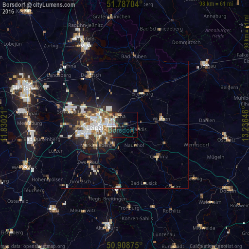
Analysis of Borsdorf night lights 2016
Square area 10x10 km:
 1.96%
1.96%90-99
3.64%80-89
1.68%70-79
0.98%60-69
2.24%50-59
2.38%40-49
3.64%30-39
2.66%20-29
7.7%10-19
14.71%0-9
58.4%Square area 50x50 km:
1.97%90-99
2.3%80-89
1.08%70-79
1.01%60-69
1.24%50-59
1.23%40-49
1.24%30-39
1.65%20-29
2.78%10-19
5.79%0-9
79.71%Clear (daylight) street map image can be seen on geolist.org.
Map coordinates:
51° 47' 13.3" North, 11° 49' 48.8" East
51° 21' 0" North, 12° 31' 60" East
50° 54' 31.5" North, 13° 14' 11.3" East
Some cities around Borsdorf sort by population:
• Leipzig
11.3 km =7 mi,  264°
264°
• Eilenburg
14 km =8.7 mi,  29°
29°
• Taucha
5.1 km =3.2 mi,  316°
316°
• Brandis
5.6 km =3.5 mi,  106°
106°
• Naunhof
8.9 km =5.5 mi,  154°
154°
• Machern
7.2 km =4.5 mi,  75°
75°
• Großpösna
9.6 km =6 mi,  194°
194°
• Bennewitz
12.6 km =7.8 mi, 84°
2946016 (p: 8,489)
Sources (retrieved 2019-11-25):
» Earth at Night: Flat Maps 2012, 2016