Biesenthal night lights from space
Night Light of Biesenthal (Brandenburg) from space (Germany) Src. Average luminocity for 10x10km area is 0.5846% and for 50x50km: 9.693%.
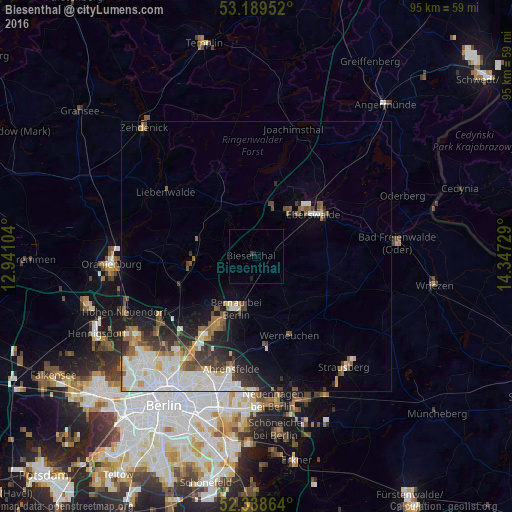
Analysis of Biesenthal night lights 2016
Square area 10x10 km:
 0%
0%90-99
0%80-89
0%70-79
0%60-69
0%50-59
0%40-49
0%30-39
0.51%20-29
0%10-19
1.01%0-9
98.48%Square area 50x50 km:
2.46%90-99
2.4%80-89
0.72%70-79
0.66%60-69
0.96%50-59
1.19%40-49
1.36%30-39
1.32%20-29
1.72%10-19
3.43%0-9
83.78%Clear (daylight) street map image can be seen on geolist.org.
Map coordinates:
53° 11' 22.3" North, 12° 56' 27.7" East
52° 45' 58.2" North, 13° 38' 39" East
52° 20' 19.1" North, 14° 20' 50.2" East
Some cities around Biesenthal sort by population:
• Eberswalde
14.1 km =8.8 mi,  57°
57°
• Bernau bei Berlin
10.3 km =6.4 mi,  201°
201°
• Wandlitz
12.8 km =8 mi,  257°
257°
• Karow
20.6 km =12.8 mi,  212°
212°
• Buch
17.7 km =11 mi, 214°
• Altlandsberg
23.1 km =14.4 mi,  165°
165°
• Werneuchen
16 km =9.9 mi,  157°
157°
• Blankenburg
23.1 km =14.4 mi, 213°
2949046 (p: 5,512)
Sources (retrieved 2019-11-25):
» Earth at Night: Flat Maps 2012, 2016