Karow night lights from space
Night Light of Karow (Berlin) from space (Germany) Src. Average luminocity for 10x10km area is 53.2368% and for 50x50km: 32.3313%.
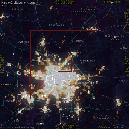
Analysis of Karow night lights 2016
Square area 10x10 km:
 9.13%
9.13%90-99
9.92%80-89
7.28%70-79
4.89%60-69
7.54%50-59
9.13%40-49
8.99%30-39
13.49%20-29
19.05%10-19
10.58%0-9
0%Square area 50x50 km:
9.91%90-99
8.41%80-89
3.23%70-79
2.7%60-69
2.84%50-59
2.75%40-49
3.21%30-39
3.66%20-29
5.47%10-19
9.86%0-9
47.95%Clear (daylight) street map image can be seen on geolist.org.
Map coordinates:
53° 2' 2.1" North, 12° 46' 41" East
52° 36' 32.5" North, 13° 28' 52.2" East
52° 10' 47.9" North, 14° 11' 3.5" East
Some cities around Karow sort by population:
• Pankow
6.9 km =4.3 mi,  230°
230°
• Neu-Hohenschönhausen
5.2 km =3.2 mi,  155°
155°
• Weißensee
5.9 km =3.7 mi,  189°
189°
• Niederschönhausen
5.9 km =3.7 mi,  243°
243°
• Französisch Buchholz
3.5 km =2.2 mi,  257°
257°
• Buch
3 km =1.9 mi,  20°
20°
• Blankenburg
2.5 km =1.6 mi,  224°
224°
• Heinersdorf
5.1 km =3.2 mi, 215°
2892705 (p: 18,817)
Sources (retrieved 2019-11-25):
» Earth at Night: Flat Maps 2012, 2016