Buch night lights from space
Night Light of Buch (Berlin) from space (Germany) Src. Average luminocity for 10x10km area is 37.5463% and for 50x50km: 30.007%.
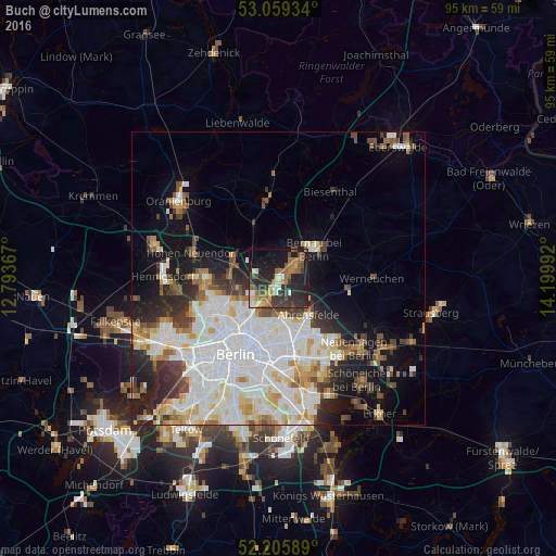
Analysis of Buch night lights 2016
Square area 10x10 km:
 3.44%
3.44%90-99
3.57%80-89
4.63%70-79
3.84%60-69
7.67%50-59
8.6%40-49
5.29%30-39
8.73%20-29
18.92%10-19
26.98%0-9
8.33%Square area 50x50 km:
9.43%90-99
7.82%80-89
2.96%70-79
2.42%60-69
2.57%50-59
2.61%40-49
2.97%30-39
3.02%20-29
4.78%10-19
9.19%0-9
52.21%Clear (daylight) street map image can be seen on geolist.org.
Map coordinates:
53° 3' 33.6" North, 12° 47' 37.2" East
52° 38' 4.9" North, 13° 29' 48.4" East
52° 12' 21.2" North, 14° 11' 59.7" East
Some cities around Buch sort by population:
• Neu-Hohenschönhausen
7.6 km =4.7 mi,  171°
171°
• Bernau bei Berlin
7.9 km =4.9 mi,  50°
50°
• Niederschönhausen
8.4 km =5.2 mi,  228°
228°
• Französisch Buchholz
5.8 km =3.6 mi, 231°
• Karow
3 km =1.9 mi,  200°
200°
• Rosenthal
8.9 km =5.5 mi,  244°
244°
• Blankenburg
5.4 km =3.4 mi,  211°
211°
• Heinersdorf
8.1 km =5 mi, 209°
2942827 (p: 12,674)
Sources (retrieved 2019-11-25):
» Earth at Night: Flat Maps 2012, 2016