Blankenburg night lights from space
Night Light of Blankenburg (Berlin) from space (Germany) Src. Average luminocity for 10x10km area is 69.9894% and for 50x50km: 34.285%.
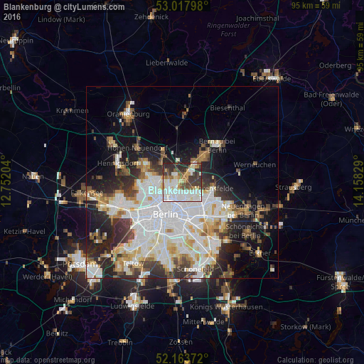
Analysis of Blankenburg night lights 2016
Square area 10x10 km:
 22.49%
90-99
19.58%80-89
7.28%70-79
5.69%60-69
5.95%50-59
6.08%40-49
8.47%30-39
12.17%20-29
12.3%10-19
0%0-9
0%Square area 50x50 km:
10.28%90-99
8.83%80-89
3.42%70-79
2.8%60-69
2.96%50-59
3.08%40-49
3.64%30-39
4.13%20-29
6.49%10-19
10.76%0-9
43.62%Clear (daylight) street map image can be seen on geolist.org.
Map coordinates:
53° 1' 4.7" North, 12° 45' 7.3" East
52° 35' 34.5" North, 13° 27' 18.6" East
52° 9' 49.4" North, 14° 9' 29.8" East
Some cities around Blankenburg sort by population:
• Pankow
4.5 km =2.8 mi,  233°
233°
• Neu-Hohenschönhausen
4.8 km =3 mi,  126°
126°
• Weißensee
4.1 km =2.5 mi,  169°
169°
• Niederschönhausen
3.7 km =2.3 mi,  255°
255°
• Französisch Buchholz
2 km =1.2 mi,  302°
302°
• Karow
2.5 km =1.6 mi,  44°
44°
• Rosenthal
5.3 km =3.3 mi,  278°
278°
• Heinersdorf
2.6 km =1.6 mi,  206°
206°
2948069 (p: 6,536)
Sources (retrieved 2019-11-25):
» Earth at Night: Flat Maps 2012, 2016