Bad Dürkheim night lights from space
Night Light of Bad Dürkheim (Rheinland-Pfalz) from space (Germany) Src. Average luminocity for 10x10km area is 10.4454% and for 50x50km: 15.7615%.
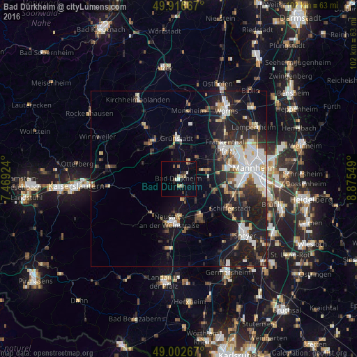
Analysis of Bad Dürkheim night lights 2016
Square area 10x10 km:
 0.28%
0.28%90-99
1.82%80-89
1.26%70-79
0%60-69
1.82%50-59
1.54%40-49
1.68%30-39
1.12%20-29
1.82%10-19
2.94%0-9
85.71%Square area 50x50 km:
3.27%90-99
3.3%80-89
1.23%70-79
1.04%60-69
1.47%50-59
1.41%40-49
2%30-39
2.19%20-29
4.87%10-19
11.98%0-9
67.25%Clear (daylight) street map image can be seen on geolist.org.
Map coordinates:
49° 55' 0" North, 7° 28' 9.3" East
49° 27' 42.5" North, 8° 10' 20.5" East
49° 0' 9.6" North, 8° 52' 31.8" East
Some cities around Bad Dürkheim sort by population:
• Neustadt
12.7 km =7.9 mi,  191°
191°
• Haßloch
12.6 km =7.8 mi,  150°
150°
• Grünstadt
11.3 km =7 mi,  356°
356°
• Herxheim am Berg
5.3 km =3.3 mi,  5°
5°
• Eisenberg
13 km =8.1 mi,  326°
326°
• Dannstadt-Schauernheim
10.1 km =6.3 mi,  103°
103°
• Maxdorf
9.1 km =5.7 mi,  71°
71°
• Lambsheim
10.1 km =6.3 mi,  55°
55°
2953522 (p: 18,698)
Sources (retrieved 2019-11-25):
» Earth at Night: Flat Maps 2012, 2016