Bad Berka night lights from space
Night Light of Bad Berka (Thuringia) from space (Germany) Src. Average luminocity for 10x10km area is 1.6092% and for 50x50km: 7.2417%.
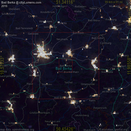
Analysis of Bad Berka night lights 2016
Square area 10x10 km:
 0%
0%90-99
0%80-89
0%70-79
0%60-69
0.98%50-59
0.14%40-49
0%30-39
0%20-29
0.28%10-19
0%0-9
98.6%Square area 50x50 km:
1.68%90-99
1.59%80-89
0.52%70-79
0.53%60-69
0.56%50-59
0.63%40-49
0.41%30-39
0.55%20-29
1.73%10-19
5.91%0-9
85.88%Clear (daylight) street map image can be seen on geolist.org.
Map coordinates:
51° 20' 28.2" North, 10° 34' 45.6" East
50° 53' 59.4" North, 11° 16' 56.8" East
50° 27' 15.3" North, 11° 59' 8.1" East
Some cities around Bad Berka sort by population:
• Erfurt
19.6 km =12.2 mi,  296°
296°
• Jena
21.8 km =13.5 mi,  81°
81°
• Weimar
9.5 km =5.9 mi,  20°
20°
• Rudolstadt
20.4 km =12.7 mi,  168°
168°
• Apolda
21.6 km =13.4 mi,  49°
49°
• Kahla
23.6 km =14.7 mi,  116°
116°
• Blankenhain
6.2 km =3.9 mi,  135°
135°
• Stadtilm
19.7 km =12.2 mi,  225°
225°
2953548 (p: 7,744)
Sources (retrieved 2019-11-25):
» Earth at Night: Flat Maps 2012, 2016