Schwieberdingen night lights from space
Night Light of Schwieberdingen (Baden-Württemberg) from space (Germany) Src. Average luminocity for 10x10km area is 35.2131% and for 50x50km: 27.9971%.
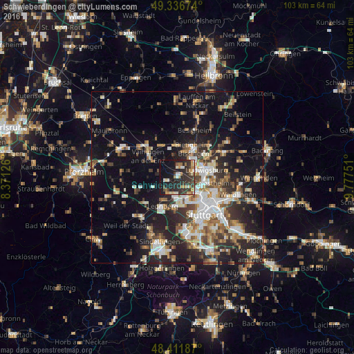
Analysis of Schwieberdingen night lights 2016
Square area 10x10 km:
 2.56%
2.56%90-99
4.97%80-89
3.55%70-79
6.39%60-69
4.97%50-59
2.13%40-49
3.55%30-39
13.07%20-29
22.44%10-19
24.15%0-9
12.22%Square area 50x50 km:
4.48%90-99
5.22%80-89
2.49%70-79
3.11%60-69
3.82%50-59
3.58%40-49
3.83%30-39
4.27%20-29
9.08%10-19
17.9%0-9
42.21%Clear (daylight) street map image can be seen on geolist.org.
Map coordinates:
49° 20' 12.3" North, 8° 22' 16.5" East
48° 52' 35.2" North, 9° 4' 27.8" East
48° 24' 42.7" North, 9° 46' 39" East
Some cities around Schwieberdingen sort by population:
• Ditzingen
5.6 km =3.5 mi,  185°
185°
• Korntal
6 km =3.7 mi,  145°
145°
• Markgröningen
3.2 km =2 mi,  8°
8°
• Asperg
5.5 km =3.4 mi,  54°
54°
• Tamm
5.7 km =3.5 mi,  31°
31°
• Möglingen
4 km =2.5 mi,  72°
72°
• Hemmingen
3.2 km =2 mi,  250°
250°
• Eberdingen
8 km =5 mi,  272°
272°
2834226 (p: 10,736)
Sources (retrieved 2019-11-25):
» Earth at Night: Flat Maps 2012, 2016