Karlín night lights from space
Night Light of Karlín (Hlavní město Praha) from space (Czech Republic) Src. Average luminocity for 10x10km area is 98.1331% and for 50x50km: 24.6525%.
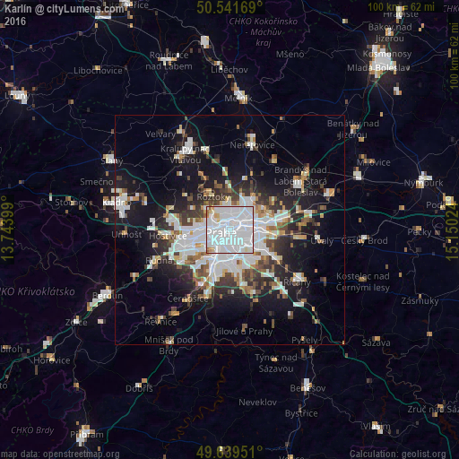
Analysis of Karlín night lights 2016
Square area 10x10 km:
 78.99%
90-99
14.85%80-89
2.8%70-79
1.26%60-69
1.26%50-59
0.84%40-49
0%30-39
0%20-29
0%10-19
0%0-9
0%Square area 50x50 km:
7.73%90-99
5.1%80-89
1.53%70-79
1.78%60-69
2.09%50-59
2.29%40-49
2.4%30-39
3.32%20-29
5.35%10-19
14.25%0-9
54.16%Clear (daylight) street map image can be seen on geolist.org.
Map coordinates:
50° 32' 30.1" North, 13° 44' 38.4" East
50° 5' 33.8" North, 14° 26' 49.6" East
49° 38' 22.2" North, 15° 9' 0.9" East
Some cities around Karlín sort by population:
• Prague
2 km =1.2 mi,  254°
254°
• Libeň
2.6 km =1.6 mi,  48°
48°
• Letňany
6.7 km =4.2 mi, 47°
• Prosek
4.9 km =3 mi,  59°
59°
• Střížkov
5 km =3.1 mi,  41°
41°
• Vysočany
5.3 km =3.3 mi,  69°
69°
• Staré Město
2 km =1.2 mi, 251°
• Malá Strana
3.1 km =1.9 mi,  259°
259°
3073838 (p: 11,971)
Sources (retrieved 2019-11-25):
» Earth at Night: Flat Maps 2012, 2016