Slavkov u Brna night lights from space
Night Light of Slavkov u Brna (South Moravian) from space (Czech Republic) Src. Average luminocity for 10x10km area is 8.1499% and for 50x50km: 9.0003%.
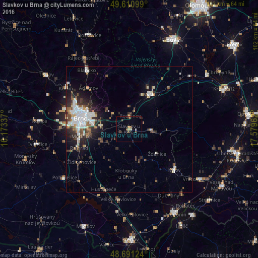
Analysis of Slavkov u Brna night lights 2016
Square area 10x10 km:
 0.42%
0.42%90-99
0.7%80-89
1.12%70-79
0.7%60-69
1.54%50-59
0.7%40-49
1.54%30-39
1.12%20-29
3.36%10-19
0.56%0-9
88.24%Square area 50x50 km:
1.83%90-99
1.95%80-89
0.54%70-79
0.7%60-69
0.87%50-59
1%40-49
1.25%30-39
1.48%20-29
2.75%10-19
3.78%0-9
83.85%Clear (daylight) street map image can be seen on geolist.org.
Map coordinates:
49° 36' 39.6" North, 16° 10' 24.1" East
49° 9' 11.7" North, 16° 52' 35.4" East
48° 41' 28.5" North, 17° 34' 46.6" East
Some cities around Slavkov u Brna sort by population:
• Brno
20.1 km =12.5 mi,  283°
283°
• Vyškov
16.4 km =10.2 mi,  32°
32°
• Blansko
28.8 km =17.9 mi,  324°
324°
• Kyjov
24 km =14.9 mi,  131°
131°
• Šlapanice
11 km =6.8 mi, 278°
• Bučovice
9.1 km =5.7 mi,  92°
92°
• Hustopeče
25.7 km =16 mi,  203°
203°
• Rousínov
5.4 km =3.4 mi,  4°
4°
3065824 (p: 5,936)
Sources (retrieved 2019-11-25):
» Earth at Night: Flat Maps 2012, 2016