Kyjov night lights from space
Night Light of Kyjov (South Moravian) from space (Czech Republic) Src. Average luminocity for 10x10km area is 6.9494% and for 50x50km: 4.7502%.
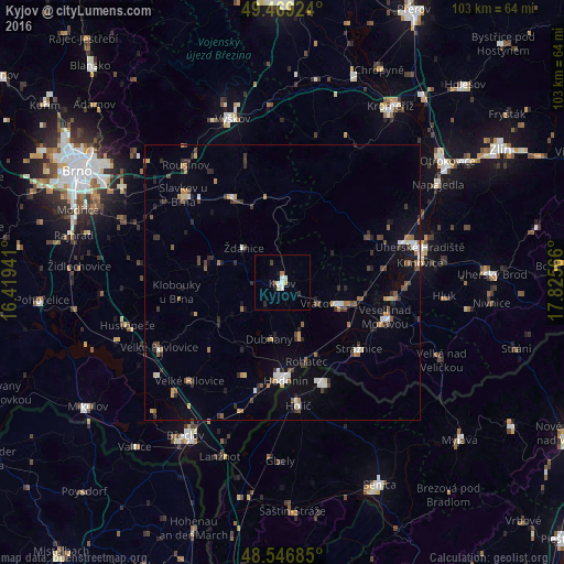
Analysis of Kyjov night lights 2016
Square area 10x10 km:
 1.19%
1.19%90-99
1.79%80-89
0.6%70-79
0.6%60-69
1.19%50-59
0%40-49
0.3%30-39
0.3%20-29
1.19%10-19
1.19%0-9
91.67%Square area 50x50 km:
0.43%90-99
0.63%80-89
0.34%70-79
0.49%60-69
0.61%50-59
0.66%40-49
0.73%30-39
0.9%20-29
1.12%10-19
1.69%0-9
92.39%Clear (daylight) street map image can be seen on geolist.org.
Map coordinates:
49° 28' 9.3" North, 16° 25' 9.9" East
49° 0' 36.6" North, 17° 7' 21.1" East
48° 32' 48.7" North, 17° 49' 32.4" East
Some cities around Kyjov sort by population:
• Hodonín
17.9 km =11.1 mi,  177°
177°
• Skalica, SK
19.9 km =12.4 mi,  157°
157°
• Veselí nad Moravou
19.6 km =12.2 mi,  108°
108°
• Holíč, SK
22.3 km =13.9 mi,  172°
172°
• Staré Město
23.8 km =14.8 mi,  72°
72°
• Dubňany
10.6 km =6.6 mi,  192°
192°
• Bučovice
17.8 km =11.1 mi,  330°
330°
• Strážnice
18.7 km =11.6 mi,  130°
130°
3072407 (p: 12,191)
Sources (retrieved 2019-11-25):
» Earth at Night: Flat Maps 2012, 2016