Rousínov night lights from space
Night Light of Rousínov (South Moravian) from space (Czech Republic) Src. Average luminocity for 10x10km area is 7.1905% and for 50x50km: 8.8797%.
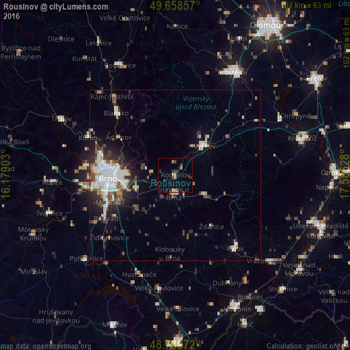
Analysis of Rousínov night lights 2016
Square area 10x10 km:
 0%
0%90-99
0%80-89
0.56%70-79
1.54%60-69
1.82%50-59
0.14%40-49
2.1%30-39
2.1%20-29
2.38%10-19
0%0-9
89.36%Square area 50x50 km:
1.82%90-99
1.92%80-89
0.49%70-79
0.72%60-69
0.85%50-59
0.97%40-49
1.23%30-39
1.48%20-29
2.67%10-19
3.68%0-9
84.15%Clear (daylight) street map image can be seen on geolist.org.
Map coordinates:
49° 39' 30.9" North, 16° 10' 44.5" East
49° 12' 4.6" North, 16° 52' 55.7" East
48° 44' 23" North, 17° 35' 7" East
Some cities around Rousínov sort by population:
• Brno
19.9 km =12.4 mi,  268°
268°
• Vyškov
12 km =7.5 mi,  45°
45°
• Blansko
24.9 km =15.5 mi,  316°
316°
• Kyjov
27.5 km =17.1 mi,  140°
140°
• Kuřim
27.7 km =17.2 mi,  293°
293°
• Šlapanice
11.8 km =7.3 mi,  252°
252°
• Bučovice
10.5 km =6.5 mi,  123°
123°
• Slavkov u Brna
5.4 km =3.4 mi,  184°
184°
3066719 (p: 5,016)
Sources (retrieved 2019-11-25):
» Earth at Night: Flat Maps 2012, 2016