Přelouč night lights from space
Night Light of Přelouč (Pardubický) from space (Czech Republic) Src. Average luminocity for 10x10km area is 6.416% and for 50x50km: 7.0001%.
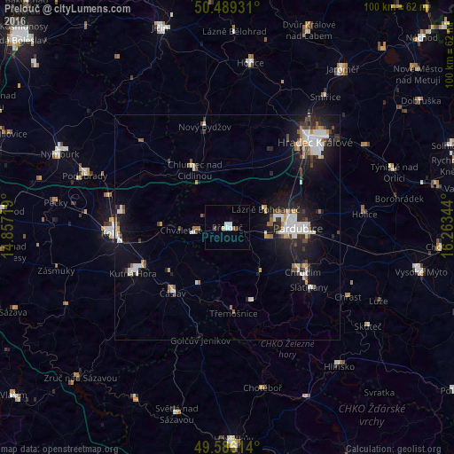
Analysis of Přelouč night lights 2016
Square area 10x10 km:
 1.96%
1.96%90-99
1.4%80-89
0.42%70-79
0.14%60-69
0%50-59
0.84%40-49
0.84%30-39
0%20-29
0.28%10-19
1.12%0-9
93%Square area 50x50 km:
1.35%90-99
1.55%80-89
0.42%70-79
0.58%60-69
0.59%50-59
0.46%40-49
1.04%30-39
0.68%20-29
1.78%10-19
5.66%0-9
85.89%Clear (daylight) street map image can be seen on geolist.org.
Map coordinates:
50° 29' 21.5" North, 14° 51' 25.9" East
50° 2' 23.5" North, 15° 33' 37.1" East
49° 35' 10.1" North, 16° 15' 48.4" East
Some cities around Přelouč sort by population:
• Hradec Králové
27.1 km =16.8 mi,  45°
45°
• Pardubice
15.4 km =9.6 mi,  89°
89°
• Kolín
25.8 km =16 mi,  267°
267°
• Chrudim
19.5 km =12.1 mi,  120°
120°
• Kutná Hora
23.2 km =14.4 mi,  244°
244°
• Čáslav
18.8 km =11.7 mi,  220°
220°
• Nový Bydžov
23 km =14.3 mi,  347°
347°
• Chlumec nad Cidlinou
14.6 km =9.1 mi,  330°
330°
3067594 (p: 8,586)
Sources (retrieved 2019-11-25):
» Earth at Night: Flat Maps 2012, 2016