Čáslav night lights from space
Night Light of Čáslav (Central Bohemia) from space (Czech Republic) Src. Average luminocity for 10x10km area is 4.5854% and for 50x50km: 3.4794%.
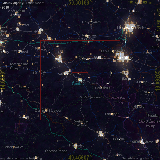
Analysis of Čáslav night lights 2016
Square area 10x10 km:
 0.84%
0.84%90-99
0.28%80-89
0.7%70-79
0.42%60-69
1.12%50-59
0.56%40-49
0.56%30-39
0%20-29
1.12%10-19
0%0-9
94.4%Square area 50x50 km:
0.53%90-99
0.64%80-89
0.24%70-79
0.45%60-69
0.35%50-59
0.31%40-49
0.37%30-39
0.32%20-29
0.57%10-19
2.53%0-9
93.69%Clear (daylight) street map image can be seen on geolist.org.
Map coordinates:
50° 21' 42" North, 14° 41' 11.8" East
49° 54' 39.6" North, 15° 23' 23" East
49° 27' 21.9" North, 16° 5' 34.3" East
Some cities around Čáslav sort by population:
• Kolín
18.8 km =11.7 mi,  313°
313°
• Chrudim
29.4 km =18.3 mi,  81°
81°
• Kutná Hora
9.6 km =6 mi,  295°
295°
• Chotěboř
29.2 km =18.1 mi,  136°
136°
• Přelouč
18.8 km =11.7 mi,  40°
40°
• Světlá nad Sázavou
27 km =16.8 mi,  177°
177°
• Ledeč nad Sázavou
25.3 km =15.7 mi,  198°
198°
• Chlumec nad Cidlinou
27.5 km =17.1 mi,  10°
10°
3078234 (p: 10,025)
Sources (retrieved 2019-11-25):
» Earth at Night: Flat Maps 2012, 2016