Nejdek night lights from space
Night Light of Nejdek (Karlovarský kraj) from space (Czech Republic) Src. Average luminocity for 10x10km area is 2.5868% and for 50x50km: 3.7938%.
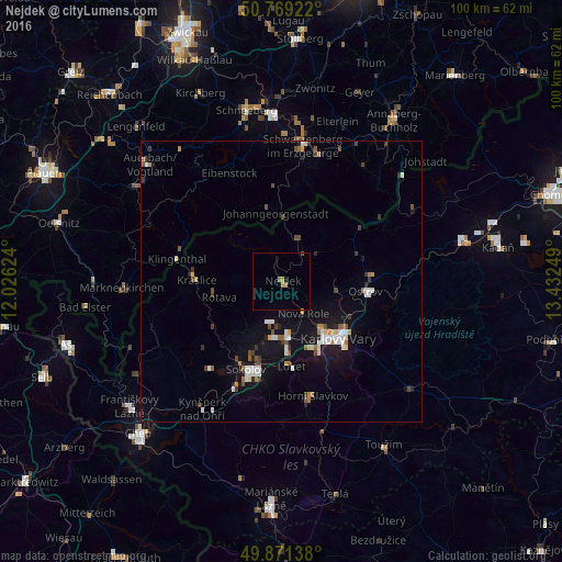
Analysis of Nejdek night lights 2016
Square area 10x10 km:
 0%
0%90-99
0%80-89
0%70-79
1.12%60-69
1.12%50-59
0%40-49
0.28%30-39
0%20-29
0%10-19
0.42%0-9
97.06%Square area 50x50 km:
0.6%90-99
0.63%80-89
0.22%70-79
0.37%60-69
0.37%50-59
0.36%40-49
0.53%30-39
0.54%20-29
0.46%10-19
3.19%0-9
92.73%Clear (daylight) street map image can be seen on geolist.org.
Map coordinates:
50° 46' 9.2" North, 12° 1' 34.5" East
50° 19' 20.7" North, 12° 43' 45.7" East
49° 52' 17" North, 13° 25' 57" East
Some cities around Nejdek sort by population:
• Karlovy Vary
14.2 km =8.8 mi,  134°
134°
• Sokolov
16.9 km =10.5 mi,  202°
202°
• Ostrov
15 km =9.3 mi,  97°
97°
• Chodov
9.2 km =5.7 mi,  172°
172°
• Klingenthal, DE
19.2 km =11.9 mi,  282°
282°
• Kraslice
15 km =9.3 mi,  270°
270°
• Johanngeorgenstadt, DE
12.3 km =7.6 mi,  354°
354°
• Habartov
20.1 km =12.5 mi,  219°
219°
3069934 (p: 8,565)
Sources (retrieved 2019-11-25):
» Earth at Night: Flat Maps 2012, 2016