Mohelnice night lights from space
Night Light of Mohelnice (Olomoucký) from space (Czech Republic) Src. Average luminocity for 10x10km area is 5.4158% and for 50x50km: 3.8627%.
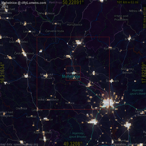
Analysis of Mohelnice night lights 2016
Square area 10x10 km:
 0.94%
0.94%90-99
1.2%80-89
0%70-79
0.13%60-69
0.8%50-59
0.13%40-49
1.6%30-39
1.2%20-29
1.74%10-19
0.27%0-9
91.98%Square area 50x50 km:
0.69%90-99
0.72%80-89
0.32%70-79
0.37%60-69
0.39%50-59
0.51%40-49
0.51%30-39
0.47%20-29
0.95%10-19
1.43%0-9
93.63%Clear (daylight) street map image can be seen on geolist.org.
Map coordinates:
50° 13' 44.1" North, 16° 12' 58.8" East
49° 46' 37.1" North, 16° 55' 10.1" East
49° 19' 14.9" North, 17° 37' 21.3" East
Some cities around Mohelnice sort by population:
• Šumperk
21.3 km =13.2 mi,  9°
9°
• Zábřeh
12.2 km =7.6 mi,  343°
343°
• Šternberk
27.7 km =17.2 mi,  100°
100°
• Uničov
14.5 km =9 mi,  92°
92°
• Moravská Třebová
18.4 km =11.4 mi,  263°
263°
• Litovel
14.1 km =8.8 mi,  126°
126°
• Lanškroun
26.7 km =16.6 mi,  304°
304°
• Rýmařov
30.6 km =19 mi,  55°
55°
3070409 (p: 9,742)
Sources (retrieved 2019-11-25):
» Earth at Night: Flat Maps 2012, 2016