Moravská Třebová night lights from space
Night Light of Moravská Třebová (Pardubický) from space (Czech Republic) Src. Average luminocity for 10x10km area is 3.893% and for 50x50km: 2.3471%.
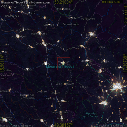
Analysis of Moravská Třebová night lights 2016
Square area 10x10 km:
 0%
0%90-99
1.07%80-89
0.94%70-79
0.67%60-69
0.53%50-59
0.53%40-49
0.53%30-39
0.13%20-29
0.13%10-19
0%0-9
95.45%Square area 50x50 km:
0.39%90-99
0.47%80-89
0.23%70-79
0.24%60-69
0.28%50-59
0.24%40-49
0.34%30-39
0.24%20-29
0.2%10-19
0.41%0-9
96.97%Clear (daylight) street map image can be seen on geolist.org.
Map coordinates:
50° 12' 36.1" North, 15° 57' 40.1" East
49° 45' 28.5" North, 16° 39' 51.3" East
49° 18' 5.7" North, 17° 22' 2.6" East
Some cities around Moravská Třebová sort by population:
• Svitavy
14.1 km =8.8 mi,  269°
269°
• Česká Třebová
22.7 km =14.1 mi,  315°
315°
• Zábřeh
20.4 km =12.7 mi,  47°
47°
• Litomyšl
28 km =17.4 mi,  295°
295°
• Lanškroun
17.6 km =10.9 mi,  347°
347°
• Mohelnice
18.4 km =11.4 mi,  83°
83°
• Polička
29.1 km =18.1 mi,  260°
260°
• Letovice
24.3 km =15.1 mi,  195°
195°
3070325 (p: 11,414)
Sources (retrieved 2019-11-25):
» Earth at Night: Flat Maps 2012, 2016