Doksy night lights from space
Night Light of Doksy (Liberecký kraj) from space (Czech Republic) Src. Average luminocity for 10x10km area is 0.8048% and for 50x50km: 4.3187%.
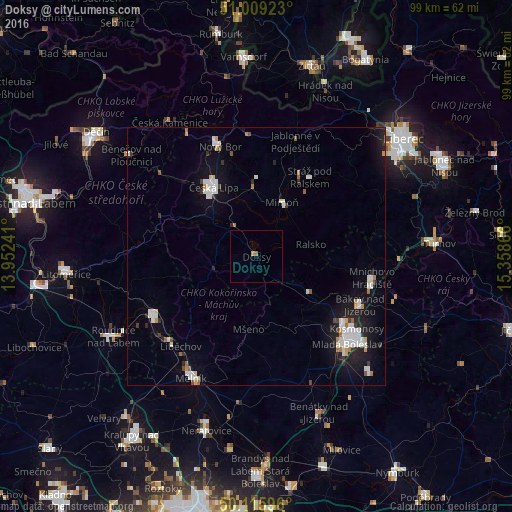
Analysis of Doksy night lights 2016
Square area 10x10 km:
 0%
0%90-99
0%80-89
0%70-79
0.53%60-69
0.53%50-59
0%40-49
0%30-39
0%20-29
0%10-19
0%0-9
98.93%Square area 50x50 km:
0.91%90-99
1.01%80-89
0.25%70-79
0.28%60-69
0.45%50-59
0.23%40-49
0.16%30-39
0.44%20-29
0.82%10-19
3.43%0-9
92.03%Clear (daylight) street map image can be seen on geolist.org.
Map coordinates:
51° 0' 33.2" North, 13° 57' 8.7" East
50° 33' 53" North, 14° 39' 19.9" East
50° 6' 57.5" North, 15° 21' 31.2" East
Some cities around Doksy sort by population:
• Mladá Boleslav
24.4 km =15.2 mi,  134°
134°
• Česká Lípa
15.8 km =9.8 mi,  328°
328°
• Mělník
27.1 km =16.8 mi,  208°
208°
• Nový Bor
22.6 km =14 mi,  341°
341°
• Štětí
23.5 km =14.6 mi,  238°
238°
• Mnichovo Hradiště
22.7 km =14.1 mi,  100°
100°
• Mimoň
11.5 km =7.1 mi,  25°
25°
• Česká Kamenice
30.9 km =19.2 mi, 327°
3076972 (p: 5,025)
Sources (retrieved 2019-11-25):
» Earth at Night: Flat Maps 2012, 2016