Nový Bor night lights from space
Night Light of Nový Bor (Liberecký kraj) from space (Czech Republic) Src. Average luminocity for 10x10km area is 6.738% and for 50x50km: 3.2339%.
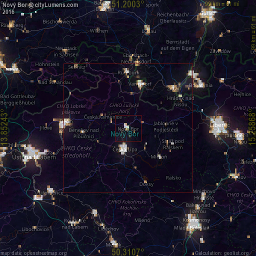
Analysis of Nový Bor night lights 2016
Square area 10x10 km:
 0.67%
0.67%90-99
1.47%80-89
0.4%70-79
0.67%60-69
0%50-59
0.94%40-49
0.13%30-39
0.94%20-29
0.13%10-19
5.88%0-9
88.77%Square area 50x50 km:
0.41%90-99
0.66%80-89
0.25%70-79
0.22%60-69
0.45%50-59
0.4%40-49
0.31%30-39
0.46%20-29
0.23%10-19
1.69%0-9
94.91%Clear (daylight) street map image can be seen on geolist.org.
Map coordinates:
51° 12' 1.1" North, 13° 51' 8.7" East
50° 45' 27.4" North, 14° 33' 20" East
50° 18' 38.5" North, 15° 15' 31.2" East
Some cities around Nový Bor sort by population:
• Česká Lípa
8.1 km =5 mi,  188°
188°
• Varnsdorf
17.7 km =11 mi,  14°
14°
• Rumburk
21.6 km =13.4 mi,  0°
0°
• Mimoň
16.2 km =10.1 mi,  132°
132°
• Großschönau, DE
18.2 km =11.3 mi,  29°
29°
• Olbersdorf, DE
19.8 km =12.3 mi,  49°
49°
• Česká Kamenice
10.7 km =6.6 mi,  294°
294°
• Doksy
22.6 km =14 mi,  161°
161°
3069381 (p: 12,171)
Sources (retrieved 2019-11-25):
» Earth at Night: Flat Maps 2012, 2016