Léfka night lights from space
Night Light of Léfka (Nicosia) from space (Cyprus) Src. Average luminocity for 10x10km area is 11.1696% and for 50x50km: 5.3096%.
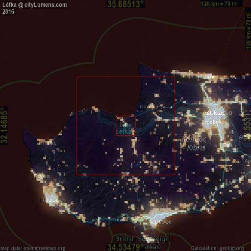
Analysis of Léfka night lights 2016
Square area 10x10 km:
100  0%
0%
90-99 0.52%
80-89 1.57%
70-79 2.1%
60-69 1.4%
50-59 2.8%
40-49 2.27%
30-39 3.15%
20-29 2.97%
10-19 1.4%
0-9 81.82%
0%90-99
0.52%80-89
1.57%70-79
2.1%60-69
1.4%50-59
2.8%40-49
2.27%30-39
3.15%20-29
2.97%10-19
1.4%0-9
81.82%Square area 50x50 km:
100 0.01%
90-99 0.36%
80-89 0.58%
70-79 1.07%
60-69 0.76%
50-59 0.81%
40-49 0.94%
30-39 1.36%
20-29 0.91%
10-19 1.42%
0-9 91.79%
0.01%90-99
0.36%80-89
0.58%70-79
1.07%60-69
0.76%50-59
0.81%40-49
0.94%30-39
1.36%20-29
0.91%10-19
1.42%0-9
91.79%Clear (daylight) street map image can be seen on geolist.org.
Map coordinates:
35° 41' 6.5" North, 32° 8' 48.7" East
35° 6' 43.2" North, 32° 50' 59.9" East
34° 32' 5.2" North, 33° 33' 11.2" East
Some cities around Léfka sort by population:
• Nicosia
47.3 km =29.4 mi,  81°
81°
• Limassol
50.6 km =31.4 mi,  160°
160°
• Kyrenia
49.2 km =30.6 mi,  59°
59°
• Mórfou
16.2 km =10.1 mi,  53°
53°
• Géri
51.8 km =32.2 mi,  90°
90°
• Ýpsonas
48.2 km =30 mi,  167°
167°
• Tséri
43.3 km =26.9 mi,  95°
95°
• Lápithos
38.7 km =24 mi, 49°
146392 (p: 7,835)
Sources (retrieved 2019-11-25):
» Earth at Night: Flat Maps 2012, 2016