Ýpsonas night lights from space
Night Light of Ýpsonas (Limassol) from space (Cyprus) Src. Average luminocity for 10x10km area is 60.5682% and for 50x50km: 11.7163%.
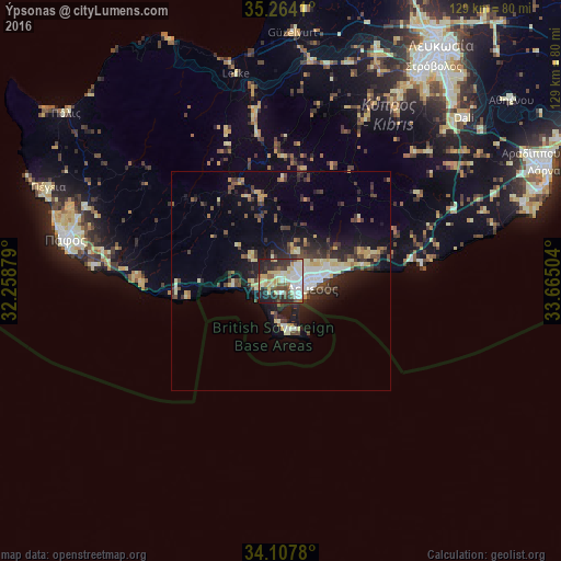
Analysis of Ýpsonas night lights 2016
Square area 10x10 km:
 9.97%
9.97%90-99
17.83%80-89
13.81%70-79
4.9%60-69
2.27%50-59
7.34%40-49
9.44%30-39
7.34%20-29
19.06%10-19
8.04%0-9
0%Square area 50x50 km:
1.26%90-99
1.87%80-89
2.17%70-79
1.11%60-69
0.53%50-59
0.96%40-49
2.65%30-39
2.58%20-29
3.53%10-19
7.21%0-9
76.12%Clear (daylight) street map image can be seen on geolist.org.
Map coordinates:
35° 15' 50.8" North, 32° 15' 31.6" East
34° 41' 16.7" North, 32° 57' 42.9" East
34° 6' 28.1" North, 33° 39' 54.1" East
Some cities around Ýpsonas sort by population:
• Limassol
7 km =4.3 mi,  93°
93°
• Paphos
50.1 km =31.1 mi,  281°
281°
• Mórfou
56.9 km =35.4 mi,  2°
2°
• Geroskipou
47.2 km =29.3 mi, 279°
• Léfka
48.2 km =30 mi,  347°
347°
• Dáli
56.1 km =34.9 mi,  48°
48°
• Tséri
54 km =33.6 mi,  37°
37°
• Dhromolaxia
60.8 km =37.8 mi,  69°
69°
145952 (p: 7,348)
Sources (retrieved 2019-11-25):
» Earth at Night: Flat Maps 2012, 2016