Géri night lights from space
Night Light of Géri (Nicosia) from space (Cyprus) Src. Average luminocity for 10x10km area is 52.1049% and for 50x50km: 25.7348%.
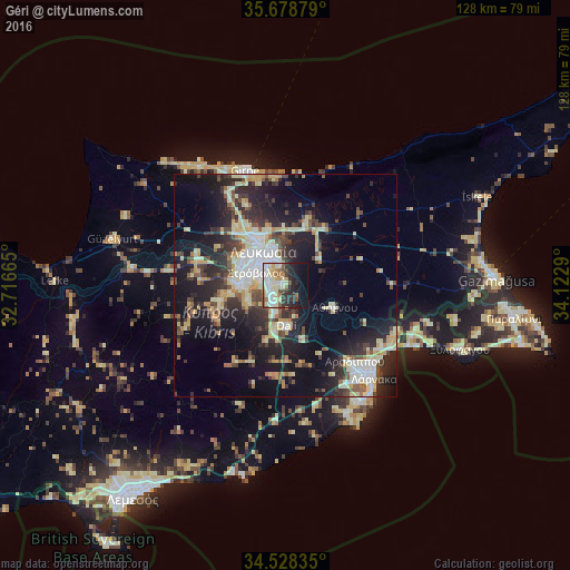
Analysis of Géri night lights 2016
Square area 10x10 km:
 11.71%
90-99
14.34%80-89
9.44%70-79
3.5%60-69
4.72%50-59
4.55%40-49
4.37%30-39
6.29%20-29
13.46%10-19
16.96%0-9
10.66%Square area 50x50 km:
3.09%90-99
5.46%80-89
4.26%70-79
2.86%60-69
1.87%50-59
2.31%40-49
3.87%30-39
4.41%20-29
9.23%10-19
16.96%0-9
45.66%Clear (daylight) street map image can be seen on geolist.org.
Map coordinates:
35° 40' 43.6" North, 32° 42' 59.9" East
35° 6' 20.2" North, 33° 25' 11.2" East
34° 31' 42.1" North, 34° 7' 22.4" East
Some cities around Géri sort by population:
• Nicosia
9.3 km =5.8 mi,  326°
326°
• Larnaca
27.5 km =17.1 mi,  137°
137°
• Kyrenia
27.3 km =17 mi,  340°
340°
• Pérgamos
27.2 km =16.9 mi,  105°
105°
• Aradíppou
23.2 km =14.4 mi, 137°
• Dáli
9.2 km =5.7 mi,  178°
178°
• Tséri
9.5 km =5.9 mi,  247°
247°
• Livádia
25.5 km =15.8 mi,  132°
132°
145964 (p: 7,639)
Sources (retrieved 2019-11-25):
» Earth at Night: Flat Maps 2012, 2016