Alacranes night lights from space
Night Light of Alacranes (Matanzas) from space (Cuba) Src. Average luminocity for 10x10km area is 3.6865% and for 50x50km: 1.0493%.
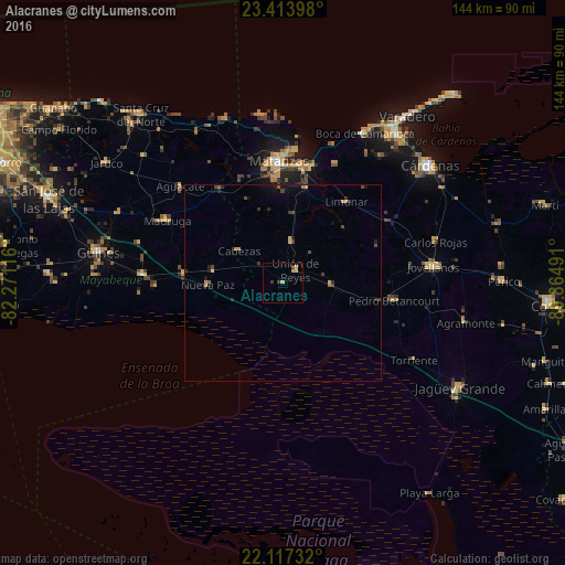
Analysis of Alacranes night lights 2016
Square area 10x10 km:
 0%
0%90-99
0%80-89
1.59%70-79
0.99%60-69
0.6%50-59
0%40-49
0%30-39
2.38%20-29
0%10-19
0%0-9
94.44%Square area 50x50 km:
0%90-99
0%80-89
0.19%70-79
0.25%60-69
0.1%50-59
0.1%40-49
0.32%30-39
0.29%20-29
0.34%10-19
0.42%0-9
97.99%Clear (daylight) street map image can be seen on geolist.org.
Map coordinates:
23° 24' 50.3" North, 82° 16' 16.2" West
22° 46' 1.9" North, 81° 34' 4.9" West
22° 7' 2.4" North, 80° 51' 53.7" West
Some cities around Alacranes sort by population:
• Matanzas
30.5 km =19 mi,  358°
358°
• Jovellanos
38.8 km =24.1 mi,  83°
83°
• Madruga
33.5 km =20.8 mi,  298°
298°
• Unión de Reyes
4.5 km =2.8 mi,  46°
46°
• Pedro Betancourt
28.9 km =18 mi,  98°
98°
• Limonar
26 km =16.2 mi,  38°
38°
• San Nicolás de Bari
35.5 km =22.1 mi,  273°
273°
• Bolondrón
12.3 km =7.6 mi,  92°
92°
3569379 (p: 5,843)
Sources (retrieved 2019-11-25):
» Earth at Night: Flat Maps 2012, 2016