San Nicolás de Bari night lights from space
Night Light of San Nicolás de Bari (Mayabeque) from space (Cuba) Src. Average luminocity for 10x10km area is 8.8353% and for 50x50km: 3.6365%.
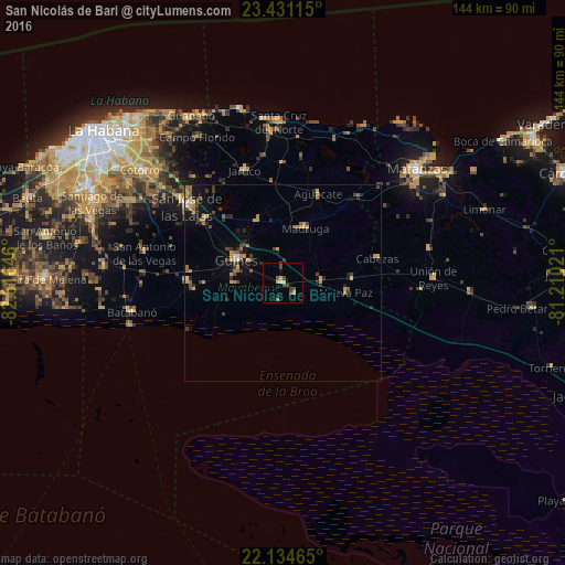
Analysis of San Nicolás de Bari night lights 2016
Square area 10x10 km:
 0%
0%90-99
0.79%80-89
1.39%70-79
1.79%60-69
0.79%50-59
0.79%40-49
5.16%30-39
0.79%20-29
0.79%10-19
1.98%0-9
85.71%Square area 50x50 km:
0.06%90-99
0.21%80-89
0.36%70-79
0.92%60-69
0.67%50-59
0.42%40-49
0.97%30-39
0.64%20-29
0.81%10-19
1.64%0-9
93.3%Clear (daylight) street map image can be seen on geolist.org.
Map coordinates:
23° 25' 52.1" North, 82° 36' 59.3" West
22° 47' 4" North, 81° 54' 48" West
22° 8' 4.7" North, 81° 12' 36.8" West
Some cities around San Nicolás de Bari sort by population:
• Güines
13 km =8.1 mi,  296°
296°
• San José de las Lajas
31.3 km =19.4 mi,  308°
308°
• Madruga
15.1 km =9.4 mi,  22°
22°
• Unión de Reyes
38.7 km =24 mi,  88°
88°
• Jaruco
30.5 km =19 mi,  341°
341°
• Jamaica
33.7 km =20.9 mi, 309°
• Batabanó
39.3 km =24.4 mi,  259°
259°
• Alacranes
35.5 km =22.1 mi, 93°
3538758 (p: 14,914)
Sources (retrieved 2019-11-25):
» Earth at Night: Flat Maps 2012, 2016