Río Segundo night lights from space
Night Light of Río Segundo (Alajuela) from space (Costa Rica) Src. Average luminocity for 10x10km area is 0% and for 50x50km: 11.1874%.
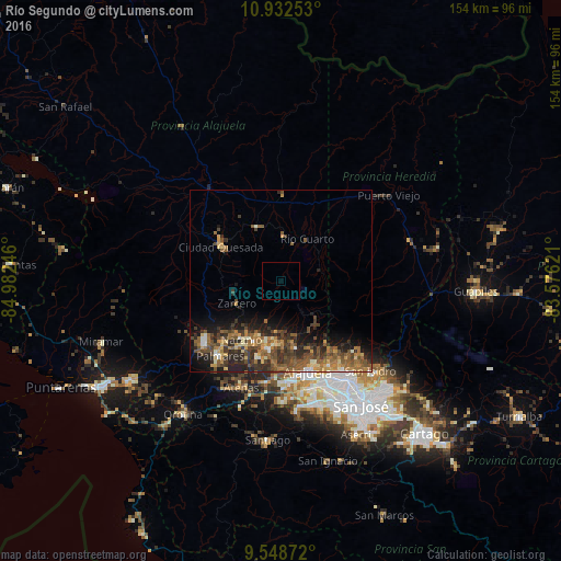
Analysis of Río Segundo night lights 2016
Square area 10x10 km:
 0%
0%90-99
0%80-89
0%70-79
0%60-69
0%50-59
0%40-49
0%30-39
0%20-29
0%10-19
0%0-9
100%Square area 50x50 km:
0.44%90-99
1.06%80-89
1.22%70-79
1.44%60-69
2.4%50-59
2.92%40-49
3.01%30-39
2.82%20-29
4.01%10-19
5.25%0-9
75.44%Clear (daylight) street map image can be seen on geolist.org.
Map coordinates:
10° 55' 57.1" North, 84° 58' 56.9" West
10° 14' 29" North, 84° 16' 45.6" West
9° 32' 55.4" North, 83° 34' 34.4" West
Some cities around Río Segundo sort by population:
• Alajuela
26.1 km =16.2 mi,  163°
163°
• Quesada
18.6 km =11.6 mi,  299°
299°
• Mercedes
30.5 km =19 mi,  148°
148°
• Naranjo
19.2 km =11.9 mi,  214°
214°
• San Ramón
27 km =16.8 mi,  230°
230°
• San Juan
16 km =9.9 mi,  194°
194°
• Llorente
30.3 km =18.8 mi, 153°
• Santo Domingo
24 km =14.9 mi, 145°
3622074 (p: 9,853)
Sources (retrieved 2019-11-25):
» Earth at Night: Flat Maps 2012, 2016