Llorente night lights from space
Night Light of Llorente (Heredia) from space (Costa Rica) Src. Average luminocity for 10x10km area is 89.8306% and for 50x50km: 31.2019%.
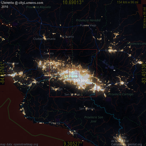
Analysis of Llorente night lights 2016
Square area 10x10 km:
 39.67%
90-99
26.86%80-89
10.74%70-79
9.5%60-69
8.26%50-59
4.75%40-49
0.21%30-39
0%20-29
0%10-19
0%0-9
0%Square area 50x50 km:
7.55%90-99
6.1%80-89
3.07%70-79
2.97%60-69
4.76%50-59
4.37%40-49
4.55%30-39
5.1%20-29
6.8%10-19
9.44%0-9
45.28%Clear (daylight) street map image can be seen on geolist.org.
Map coordinates:
10° 41' 24.5" North, 84° 51' 27.4" West
9° 59' 54.4" North, 84° 9' 16.1" West
9° 18' 19" North, 83° 27' 4.9" West
Some cities around Llorente sort by population:
• San Francisco
2.8 km =1.7 mi,  102°
102°
• Alajuela
6.6 km =4.1 mi,  287°
287°
• Mercedes
2.4 km =1.5 mi,  67°
67°
• Heredia
4.2 km =2.6 mi,  84°
84°
• San Pablo
6.4 km =4 mi,  92°
92°
• San Josecito
6.3 km =3.9 mi, 71°
• San Antonio
3.6 km =2.2 mi,  241°
241°
• San Rafael
6.2 km =3.9 mi, 74°
3623032 (p: 6,626)
Sources (retrieved 2019-11-25):
» Earth at Night: Flat Maps 2012, 2016