Nicoya night lights from space
Night Light of Nicoya (Guanacaste) from space (Costa Rica) Src. Average luminocity for 10x10km area is 10.7128% and for 50x50km: 1.342%.
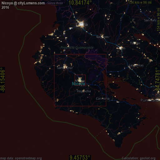
Analysis of Nicoya night lights 2016
Square area 10x10 km:
 0%
0%90-99
0.83%80-89
2.27%70-79
1.86%60-69
1.65%50-59
3.31%40-49
1.45%30-39
1.03%20-29
2.27%10-19
1.03%0-9
84.3%Square area 50x50 km:
0%90-99
0.13%80-89
0.14%70-79
0.13%60-69
0.12%50-59
0.37%40-49
0.32%30-39
0.44%20-29
0.47%10-19
0.31%0-9
97.57%Clear (daylight) street map image can be seen on geolist.org.
Map coordinates:
10° 50' 30.3" North, 86° 9' 14.6" West
10° 9' 1.4" North, 85° 27' 3.3" West
9° 27' 27.1" North, 84° 44' 52.1" West
Some cities around Nicoya sort by population:
• Liberia
53.9 km =33.5 mi,  1°
1°
• Puntarenas
69.8 km =43.4 mi,  106°
106°
• Chacarita
75.9 km =47.2 mi,  104°
104°
• Cañas
49.6 km =30.8 mi,  51°
51°
• Esparza
87.8 km =54.6 mi, 101°
• Santa Cruz
19.1 km =11.9 mi,  309°
309°
• Tilarán
63.5 km =39.5 mi,  56°
56°
• Miramar
79.2 km =49.2 mi,  94°
94°
3622716 (p: 15,313)
Sources (retrieved 2019-11-25):
» Earth at Night: Flat Maps 2012, 2016