Miramar night lights from space
Night Light of Miramar (Puntarenas) from space (Costa Rica) Src. Average luminocity for 10x10km area is 8.969% and for 50x50km: 5.573%.
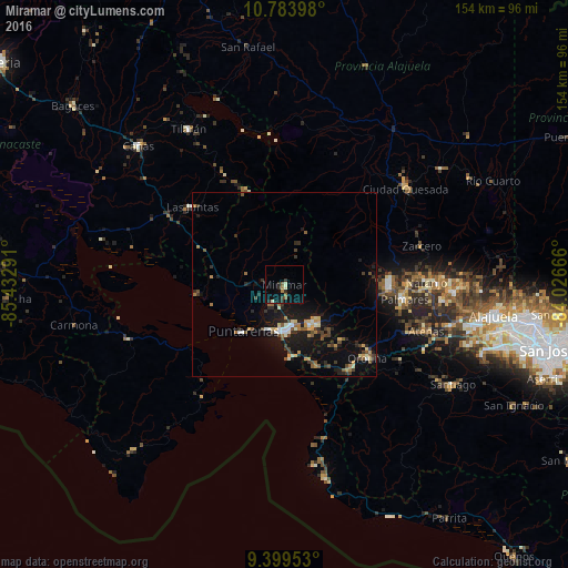
Analysis of Miramar night lights 2016
Square area 10x10 km:
 0%
0%90-99
1.65%80-89
0.83%70-79
0.41%60-69
2.27%50-59
0.83%40-49
1.24%30-39
1.65%20-29
3.51%10-19
2.07%0-9
85.54%Square area 50x50 km:
0.31%90-99
0.7%80-89
0.48%70-79
0.79%60-69
0.65%50-59
0.75%40-49
0.99%30-39
1.1%20-29
1.36%10-19
5.29%0-9
87.57%Clear (daylight) street map image can be seen on geolist.org.
Map coordinates:
10° 47' 2.3" North, 85° 25' 58.5" West
10° 5' 33" North, 84° 43' 47.2" West
9° 23' 58.3" North, 84° 1' 36" West
Some cities around Miramar sort by population:
• Puntarenas
17.6 km =10.9 mi,  222°
222°
• Chacarita
13.2 km =8.2 mi,  204°
204°
• Esparza
13 km =8.1 mi,  146°
146°
• Desamparados
29.3 km =18.2 mi,  123°
123°
• Naranjo
38.5 km =23.9 mi,  88°
88°
• San Ramón
28.4 km =17.6 mi, 91°
• Atenas
40.6 km =25.2 mi,  108°
108°
• Orotina
30.2 km =18.8 mi,  131°
131°
3622854 (p: 6,540)
Sources (retrieved 2019-11-25):
» Earth at Night: Flat Maps 2012, 2016