Desamparados night lights from space
Night Light of Desamparados (Alajuela) from space (Costa Rica) Src. Average luminocity for 10x10km area is 12.2417% and for 50x50km: 13.0747%.
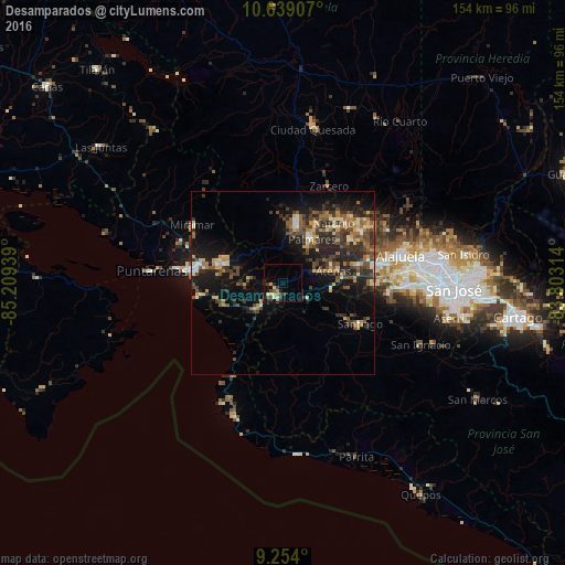
Analysis of Desamparados night lights 2016
Square area 10x10 km:
 0%
0%90-99
1.45%80-89
2.69%70-79
2.48%60-69
0.21%50-59
1.65%40-49
1.65%30-39
5.17%20-29
2.89%10-19
1.86%0-9
79.96%Square area 50x50 km:
0.46%90-99
1.41%80-89
1.5%70-79
1.61%60-69
1.95%50-59
2.28%40-49
3.21%30-39
3.44%20-29
4.9%10-19
9.31%0-9
69.92%Clear (daylight) street map image can be seen on geolist.org.
Map coordinates:
10° 38' 20.7" North, 85° 12' 33.8" West
9° 56' 50.2" North, 84° 30' 22.5" West
9° 15' 14.4" North, 83° 48' 11.3" West
Some cities around Desamparados sort by population:
• San Rafael Abajo
27 km =16.8 mi,  118°
118°
• Esparza
18.1 km =11.2 mi,  286°
286°
• Naranjo
21.9 km =13.6 mi,  39°
39°
• San Ramón
16.1 km =10 mi,  14°
14°
• Santiago
23.8 km =14.8 mi, 118°
• San Juan
27 km =16.8 mi,  50°
50°
• Atenas
14.3 km =8.9 mi,  77°
77°
• Orotina
4.3 km =2.7 mi,  205°
205°
3623935 (p: 14,448)
Sources (retrieved 2019-11-25):
» Earth at Night: Flat Maps 2012, 2016