Guápiles night lights from space
Night Light of Guápiles (Limón) from space (Costa Rica) Src. Average luminocity for 10x10km area is 25.9917% and for 50x50km: 3.7392%.
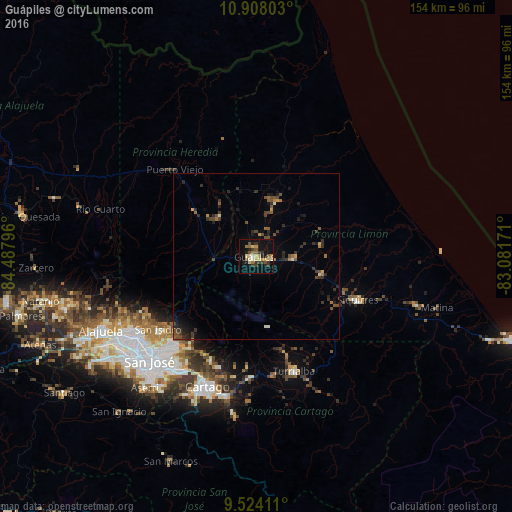
Analysis of Guápiles night lights 2016
Square area 10x10 km:
 0.62%
0.62%90-99
2.89%80-89
5.79%70-79
2.89%60-69
3.72%50-59
4.13%40-49
3.93%30-39
7.23%20-29
2.89%10-19
27.07%0-9
38.84%Square area 50x50 km:
0.03%90-99
0.27%80-89
0.35%70-79
0.34%60-69
0.51%50-59
0.66%40-49
1.04%30-39
1.19%20-29
1.2%10-19
2.36%0-9
92.06%Clear (daylight) street map image can be seen on geolist.org.
Map coordinates:
10° 54' 28.9" North, 84° 29' 16.7" West
10° 13' 0.6" North, 83° 47' 5.4" West
9° 31' 26.8" North, 83° 4' 54.2" West
Some cities around Guápiles sort by population:
• Purral
39.4 km =24.5 mi,  223°
223°
• Turrialba
36.4 km =22.6 mi,  162°
162°
• Ipís
37.3 km =23.2 mi, 222°
• Siquirres
33.2 km =20.6 mi,  113°
113°
• Concepción
39.4 km =24.5 mi, 216°
• Guácimo
10.6 km =6.6 mi,  92°
92°
• Cot
37.1 km =23.1 mi,  195°
195°
• Pocora
20.4 km =12.7 mi,  104°
104°
3623580 (p: 19,092)
Sources (retrieved 2019-11-25):
» Earth at Night: Flat Maps 2012, 2016