Turbaná night lights from space
Night Light of Turbaná (Bolívar) from space (Colombia) Src. Average luminocity for 10x10km area is 24.6508% and for 50x50km: 11.3959%.
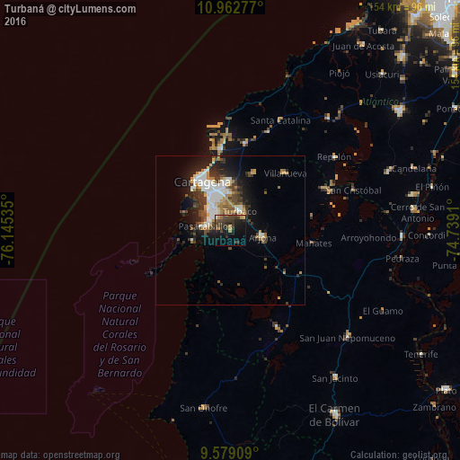
Analysis of Turbaná night lights 2016
Square area 10x10 km:
 0.83%
0.83%90-99
0.41%80-89
0.62%70-79
4.75%60-69
3.72%50-59
1.03%40-49
12.19%30-39
12.81%20-29
9.09%10-19
20.04%0-9
34.5%Square area 50x50 km:
2.27%90-99
1.95%80-89
0.83%70-79
1.26%60-69
1.68%50-59
0.79%40-49
1.99%30-39
2.62%20-29
2.89%10-19
6.36%0-9
77.36%Clear (daylight) street map image can be seen on geolist.org.
Map coordinates:
10° 57' 46" North, 76° 8' 43.3" West
10° 16' 18.1" North, 75° 26' 32" West
9° 34' 44.7" North, 74° 44' 20.8" West
Some cities around Turbaná sort by population:
• Cartagena
16.3 km =10.1 mi,  330°
330°
• Arjona
10.9 km =6.8 mi,  100°
100°
• San Pablo
31 km =19.3 mi,  142°
142°
• Villanueva
26.6 km =16.5 mi,  44°
44°
• San Estanislao
34.8 km =21.6 mi,  66°
66°
• Santa Rosa
20.8 km =12.9 mi,  22°
22°
• Mahates
27.9 km =17.3 mi, 98°
• Clemencia
35.2 km =21.9 mi, 21°
3666575 (p: 10,235)
Sources (retrieved 2019-11-25):
» Earth at Night: Flat Maps 2012, 2016