San Pablo night lights from space
Night Light of San Pablo (Bolívar) from space (Colombia) Src. Average luminocity for 10x10km area is 1.5207% and for 50x50km: 1.6927%.
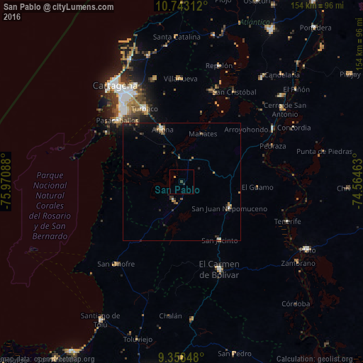
Analysis of San Pablo night lights 2016
Square area 10x10 km:
 0%
0%90-99
0%80-89
0%70-79
0.83%60-69
0%50-59
0%40-49
0%30-39
1.45%20-29
0.21%10-19
0%0-9
97.52%Square area 50x50 km:
0.06%90-99
0.18%80-89
0.07%70-79
0.29%60-69
0.29%50-59
0.24%40-49
0.35%30-39
0.56%20-29
0.51%10-19
0.69%0-9
96.78%Clear (daylight) street map image can be seen on geolist.org.
Map coordinates:
10° 44' 35.2" North, 75° 58' 15.2" West
10° 3' 5.5" North, 75° 16' 3.9" West
9° 21' 30.5" North, 74° 33' 52.7" West
Some cities around San Pablo sort by population:
• Turbaco
34.7 km =21.6 mi,  333°
333°
• Arjona
24.1 km =15 mi,  339°
339°
• San Juan Nepomuceno
23.2 km =14.4 mi,  118°
118°
• María la Baja
8.5 km =5.3 mi,  205°
205°
• San Jacinto
29.6 km =18.4 mi,  147°
147°
• Turbaná
31 km =19.3 mi,  322°
322°
• Mahates
21.9 km =13.6 mi,  22°
22°
• Soplaviento
40.4 km =25.1 mi, 20°
3669188 (p: 13,983)
Sources (retrieved 2019-11-25):
» Earth at Night: Flat Maps 2012, 2016