San Bernardo del Viento night lights from space
Night Light of San Bernardo del Viento (Córdoba) from space (Colombia) Src. Average luminocity for 10x10km area is 1.2446% and for 50x50km: 0.9958%.
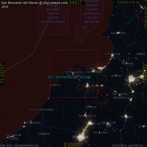
Analysis of San Bernardo del Viento night lights 2016
Square area 10x10 km:
 0%
0%90-99
0%80-89
0%70-79
0%60-69
0%50-59
0.87%40-49
0.87%30-39
0.87%20-29
0%10-19
0%0-9
97.4%Square area 50x50 km:
0.06%90-99
0.04%80-89
0.05%70-79
0.22%60-69
0.17%50-59
0.14%40-49
0.23%30-39
0.37%20-29
0.14%10-19
0.03%0-9
98.55%Clear (daylight) street map image can be seen on geolist.org.
Map coordinates:
10° 2' 46.9" North, 76° 39' 20.1" West
9° 21' 11.9" North, 75° 57' 8.8" West
8° 39' 31.9" North, 75° 14' 57.6" West
Some cities around San Bernardo del Viento sort by population:
• Lorica
20 km =12.4 mi,  130°
130°
• Santiago de Tolú
44.9 km =27.9 mi,  65°
65°
• San Antero
21.4 km =13.3 mi,  83°
83°
• Purísima de la Concepción
28.4 km =17.6 mi,  117°
117°
• Momil
33.1 km =20.6 mi,  112°
112°
• San Pelayo
45.7 km =28.4 mi,  163°
163°
• Palmito
45.1 km =28 mi,  93°
93°
• Buenavista
34.2 km =21.3 mi,  189°
189°
3670018 (p: 8,967)
Sources (retrieved 2019-11-25):
» Earth at Night: Flat Maps 2012, 2016