Palmito night lights from space
Night Light of Palmito (Sucre) from space (Colombia) Src. Average luminocity for 10x10km area is 0.7619% and for 50x50km: 5.1596%.
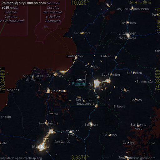
Analysis of Palmito night lights 2016
Square area 10x10 km:
 0%
0%90-99
0%80-89
0%70-79
0.87%60-69
0%50-59
0%40-49
0%30-39
0%20-29
0%10-19
0%0-9
99.13%Square area 50x50 km:
0.68%90-99
0.54%80-89
0.2%70-79
0.77%60-69
1.1%50-59
0.31%40-49
0.69%30-39
1.18%20-29
1.16%10-19
4.14%0-9
89.24%Clear (daylight) street map image can be seen on geolist.org.
Map coordinates:
10° 1' 30" North, 76° 14' 41.4" West
9° 19' 54.8" North, 75° 32' 30.1" West
8° 38' 14.6" North, 74° 50' 18.9" West
Some cities around Palmito sort by population:
• Sincelejo
16.1 km =10 mi,  100°
100°
• Corozal
27.3 km =17 mi,  93°
93°
• Santiago de Tolú
21.8 km =13.5 mi,  348°
348°
• Sampués
24.1 km =15 mi,  133°
133°
• San Antero
24.3 km =15.1 mi,  281°
281°
• Tolú Viejo
17.4 km =10.8 mi,  40°
40°
• Purísima de la Concepción
22.4 km =13.9 mi,  241°
241°
• Momil
18 km =11.2 mi,  234°
234°
3673142 (p: 5,345)
Sources (retrieved 2019-11-25):
» Earth at Night: Flat Maps 2012, 2016