Santa Lucía night lights from space
Night Light of Santa Lucía (Atlántico) from space (Colombia) Src. Average luminocity for 10x10km area is 1.4773% and for 50x50km: 2.3393%.
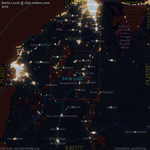
Analysis of Santa Lucía night lights 2016
Square area 10x10 km:
 0%
0%90-99
0%80-89
0%70-79
0%60-69
0%50-59
0.83%40-49
0%30-39
1.45%20-29
0.21%10-19
0%0-9
97.52%Square area 50x50 km:
0.04%90-99
0.27%80-89
0.19%70-79
0.6%60-69
0.59%50-59
0.14%40-49
0.21%30-39
0.71%20-29
0.5%10-19
0.19%0-9
96.56%Clear (daylight) street map image can be seen on geolist.org.
Map coordinates:
11° 0' 54.6" North, 75° 39' 47.9" West
10° 19' 27.1" North, 74° 57' 36.6" West
9° 37' 54.2" North, 74° 15' 25.4" West
Some cities around Santa Lucía sort by population:
• Campo de la Cruz
10.3 km =6.4 mi,  54°
54°
• Manatí
13.5 km =8.4 mi,  0°
0°
• Candelaria
17.4 km =10.8 mi,  30°
30°
• Suan
8.8 km =5.5 mi,  83°
83°
• Calamar
9.3 km =5.8 mi,  148°
148°
• Soplaviento
21.2 km =13.2 mi,  291°
291°
• El Piñón
17.3 km =10.7 mi,  59°
59°
• Cerro de San Antonio
9.9 km =6.2 mi,  88°
88°
3668655 (p: 15,760)
Sources (retrieved 2019-11-25):
» Earth at Night: Flat Maps 2012, 2016