Puerto Santander night lights from space
Night Light of Puerto Santander (Norte de Santander) from space (Colombia) Src. Average luminocity for 10x10km area is 1.157% and for 50x50km: 0.9591%.
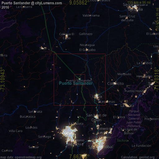
Analysis of Puerto Santander night lights 2016
Square area 10x10 km:
 0%
0%90-99
0%80-89
0%70-79
0%60-69
0.83%50-59
0.83%40-49
0%30-39
0%20-29
0%10-19
0%0-9
98.35%Square area 50x50 km:
0.11%90-99
0.09%80-89
0%70-79
0.05%60-69
0.35%50-59
0.11%40-49
0.08%30-39
0.35%20-29
0.13%10-19
0.19%0-9
98.54%Clear (daylight) street map image can be seen on geolist.org.
Map coordinates:
9° 3' 31" North, 73° 6' 33.9" West
8° 21' 49" North, 72° 24' 22.7" West
7° 40' 2.5" North, 71° 42' 11.4" West
Some cities around Puerto Santander sort by population:
• Cúcuta
53.4 km =33.2 mi,  192°
192°
• Villa del Rosario
59.4 km =36.9 mi, 187°
• Los Patios
59.4 km =36.9 mi, 190°
• Colón, VE
40.3 km =25 mi,  156°
156°
• La Fría, VE
23.9 km =14.9 mi,  133°
133°
• Tibú
47.4 km =29.5 mi,  310°
310°
• El Zulia
52.5 km =32.6 mi,  204°
204°
• Sardinata
53.5 km =33.2 mi,  234°
234°
3671325 (p: 16,275)
Sources (retrieved 2019-11-25):
» Earth at Night: Flat Maps 2012, 2016