Obando night lights from space
Night Light of Obando (Valle del Cauca) from space (Colombia) Src. Average luminocity for 10x10km area is 1.2252% and for 50x50km: 5.3152%.
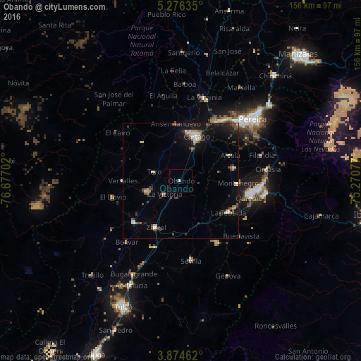
Analysis of Obando night lights 2016
Square area 10x10 km:
 0.41%
0.41%90-99
0.41%80-89
0%70-79
0%60-69
0%50-59
0%40-49
0%30-39
0%20-29
0.83%10-19
0%0-9
98.35%Square area 50x50 km:
0.6%90-99
0.69%80-89
0.33%70-79
0.61%60-69
0.57%50-59
0.86%40-49
0.93%30-39
1.01%20-29
0.93%10-19
4.3%0-9
89.16%Clear (daylight) street map image can be seen on geolist.org.
Map coordinates:
5° 16' 34.9" North, 76° 40' 37.3" West
4° 34' 33" North, 75° 58' 26" West
3° 52' 28.6" North, 75° 16' 14.8" West
Some cities around Obando sort by population:
• Cartago
20.2 km =12.6 mi,  19°
19°
• Montenegro
24.7 km =15.3 mi,  92°
92°
• Quimbaya
24 km =14.9 mi,  77°
77°
• Zarzal
22.9 km =14.2 mi,  208°
208°
• La Unión
15.1 km =9.4 mi,  251°
251°
• Toro
12.6 km =7.8 mi,  288°
288°
• La Victoria
9.2 km =5.7 mi,  231°
231°
• Alcalá
23.9 km =14.9 mi,  62°
62°
3673676 (p: 7,298)
Sources (retrieved 2019-11-25):
» Earth at Night: Flat Maps 2012, 2016