Isnos night lights from space
Night Light of Isnos (Huila) from space (Colombia) Src. Average luminocity for 10x10km area is 1.5541% and for 50x50km: 1.5957%.
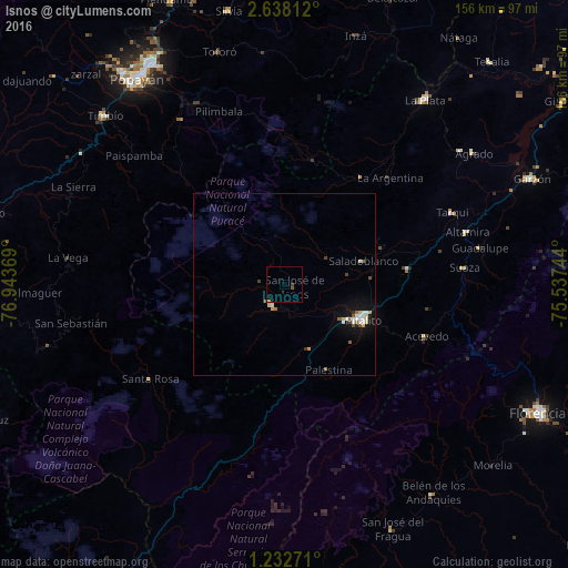
Analysis of Isnos night lights 2016
Square area 10x10 km:
100  0%
0%
90-99 0%
80-89 0%
70-79 0%
60-69 0.43%
50-59 1.08%
40-49 0.87%
30-39 0%
20-29 0%
10-19 0%
0-9 97.62%
0%90-99
0%80-89
0%70-79
0%60-69
0.43%50-59
1.08%40-49
0.87%30-39
0%20-29
0%10-19
0%0-9
97.62%Square area 50x50 km:
100 0.17%
90-99 0.4%
80-89 0.19%
70-79 0.14%
60-69 0.15%
50-59 0.27%
40-49 0.22%
30-39 0.08%
20-29 0.08%
10-19 1.16%
0-9 97.14%
0.17%90-99
0.4%80-89
0.19%70-79
0.14%60-69
0.15%50-59
0.27%40-49
0.22%30-39
0.08%20-29
0.08%10-19
1.16%0-9
97.14%Clear (daylight) street map image can be seen on geolist.org.
Map coordinates:
2° 38' 17.2" North, 76° 56' 37.3" West
1° 56' 8" North, 76° 14' 26" West
1° 13' 57.8" North, 75° 32' 14.8" West
Some cities around Isnos sort by population:
• Popayán
69.6 km =43.2 mi,  323°
323°
• Florencia
79 km =49.1 mi,  116°
116°
• Pitalito
23 km =14.3 mi,  113°
113°
• Garzón
74 km =46 mi,  66°
66°
• La Plata
63.9 km =39.7 mi,  37°
37°
• San Agustín
7 km =4.3 mi,  205°
205°
• Timaná
34.6 km =21.5 mi,  83°
83°
• Silvia
77.2 km =48 mi,  348°
348°
3792389 (p: 5,185)
Sources (retrieved 2019-11-25):
» Earth at Night: Flat Maps 2012, 2016