La Plata night lights from space
Night Light of La Plata (Huila) from space (Colombia) Src. Average luminocity for 10x10km area is 9.7424% and for 50x50km: 0.8546%.
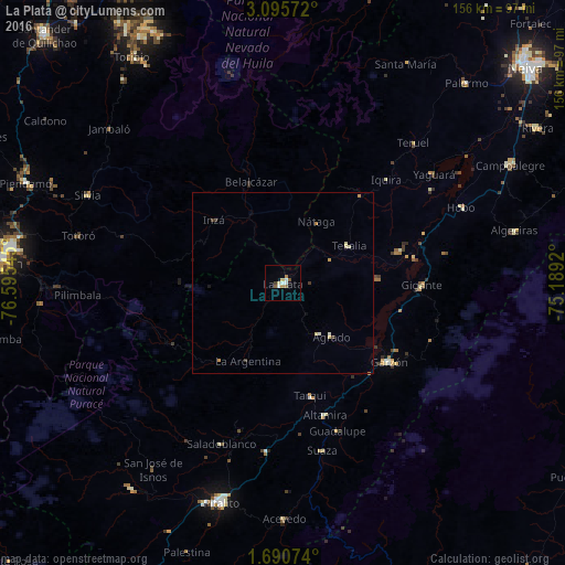
Analysis of La Plata night lights 2016
Square area 10x10 km:
 0.87%
0.87%90-99
2.6%80-89
1.08%70-79
1.3%60-69
1.52%50-59
1.3%40-49
1.52%30-39
0.22%20-29
0%10-19
0.87%0-9
88.74%Square area 50x50 km:
0.03%90-99
0.2%80-89
0.18%70-79
0.16%60-69
0.1%50-59
0.05%40-49
0.1%30-39
0.15%20-29
0%10-19
0.09%0-9
98.94%Clear (daylight) street map image can be seen on geolist.org.
Map coordinates:
3° 5' 44.6" North, 76° 35' 43.6" West
2° 23' 36.3" North, 75° 53' 32.4" West
1° 41' 26.7" North, 75° 11' 21.1" West
Some cities around La Plata sort by population:
• Pitalito
62.5 km =38.8 mi,  196°
196°
• Belalcázar
29.5 km =18.3 mi,  342°
342°
• Garzón
36.7 km =22.8 mi,  126°
126°
• Gigante
38.3 km =23.8 mi,  91°
91°
• Timaná
47.1 km =29.3 mi,  185°
185°
• Silvia
59.8 km =37.2 mi,  294°
294°
• Yaguará
51.3 km =31.9 mi,  54°
54°
• Isnos
63.9 km =39.7 mi,  217°
217°
3678097 (p: 19,275)
Sources (retrieved 2019-11-25):
» Earth at Night: Flat Maps 2012, 2016