Chinácota night lights from space
Night Light of Chinácota (Norte de Santander) from space (Colombia) Src. Average luminocity for 10x10km area is 4.7251% and for 50x50km: 2.3684%.
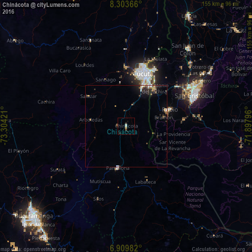
Analysis of Chinácota night lights 2016
Square area 10x10 km:
 0.65%
0.65%90-99
1.08%80-89
0%70-79
0.87%60-69
0.87%50-59
0%40-49
0%30-39
1.73%20-29
1.73%10-19
0.87%0-9
92.21%Square area 50x50 km:
0.28%90-99
0.23%80-89
0.13%70-79
0.5%60-69
0.31%50-59
0.21%40-49
0.21%30-39
0.66%20-29
0.87%10-19
1.47%0-9
95.14%Clear (daylight) street map image can be seen on geolist.org.
Map coordinates:
8° 18' 13.2" North, 73° 18' 15.2" West
7° 36' 26.3" North, 72° 36' 3.9" West
6° 54' 35.4" North, 71° 53' 52.7" West
Some cities around Chinácota sort by population:
• Cúcuta
33.5 km =20.8 mi,  17°
17°
• Villa del Rosario
28.8 km =17.9 mi,  29°
29°
• Los Patios
27.8 km =17.3 mi, 22°
• Pamplona
26.3 km =16.3 mi,  191°
191°
• Rubio, VE
29 km =18 mi,  68°
68°
• San Antonio del Táchira, VE
28.9 km =18 mi,  37°
37°
• El Zulia
36.2 km =22.5 mi,  359°
359°
• Toledo
35.5 km =22.1 mi,  158°
158°
3686574 (p: 9,667)
Sources (retrieved 2019-11-25):
» Earth at Night: Flat Maps 2012, 2016