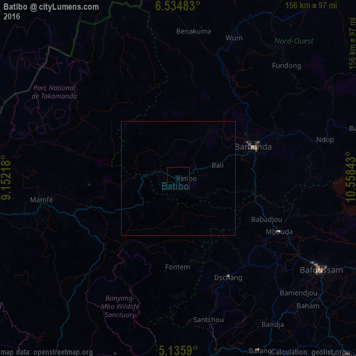
Batibo night lights from space
Night Light of Batibo (North-West) from space (Cameroon) Src. Average luminocity for 10x10km area is 0% and for 50x50km: 0%.
Analysis of Batibo night lights 2016
Square area 10x10 km:
100  0%
0%
90-99 0%
80-89 0%
70-79 0%
60-69 0%
50-59 0%
40-49 0%
30-39 0%
20-29 0%
10-19 0%
0-9 100%
0%90-99
0%80-89
0%70-79
0%60-69
0%50-59
0%40-49
0%30-39
0%20-29
0%10-19
0%0-9
100%Square area 50x50 km:
100 0%
90-99 0%
80-89 0%
70-79 0%
60-69 0%
50-59 0%
40-49 0%
30-39 0%
20-29 0%
10-19 0%
0-9 100%
0%90-99
0%80-89
0%70-79
0%60-69
0%50-59
0%40-49
0%30-39
0%20-29
0%10-19
0%0-9
100%Clear (daylight) street map image can be seen on geolist.org.
Map coordinates:
6° 32' 5.4" North, 9° 9' 7.8" East
5° 50' 8.9" North, 9° 51' 19.1" East
5° 8' 9.2" North, 10° 33' 30.3" East
Some cities around Batibo sort by population:
• Bamenda
35 km =21.7 mi,  66°
66°
• Mbouda
49.9 km =31 mi,  117°
117°
• Dschang
48.8 km =30.3 mi,  153°
153°
• Bali
18.2 km =11.3 mi, 71°
• Fontem
40.9 km =25.4 mi,  175°
175°
• Babanki
53.7 km =33.4 mi,  54°
54°
• Mbengwi
25.7 km =16 mi,  38°
38°
• Belo
54.8 km =34.1 mi, 52°
2234684 (p: 9,163)
Sources (retrieved 2019-11-25):
» Earth at Night: Flat Maps 2012, 2016