Vicuña night lights from space
Night Light of Vicuña (Coquimbo Region) from space (Chile) Src. Average luminocity for 10x10km area is 13.6496% and for 50x50km: 0.8931%.
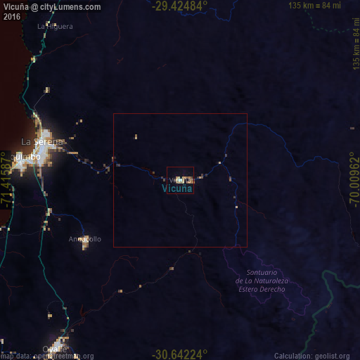
Analysis of Vicuña night lights 2016
Square area 10x10 km:
 0.76%
0.76%90-99
0.76%80-89
2.27%70-79
2.27%60-69
4.36%50-59
3.22%40-49
0.95%30-39
1.33%20-29
0%10-19
1.14%0-9
82.95%Square area 50x50 km:
0.03%90-99
0.03%80-89
0.18%70-79
0.15%60-69
0.17%50-59
0.16%40-49
0.13%30-39
0.25%20-29
0.13%10-19
0.12%0-9
98.66%Clear (daylight) street map image can be seen on geolist.org.
Map coordinates:
29° 25' 29.4" South, 71° 24' 57.1" West
30° 2' 7.5" South, 70° 42' 45.9" West
30° 38' 32.1" South, 70° 0' 34.6" West
Some cities around Vicuña sort by population:
• Coquimbo
61 km =37.9 mi,  278°
278°
• La Serena
53.7 km =33.4 mi,  285°
285°
• Ovalle
78.3 km =48.7 mi,  216°
216°
• Vallenar
162.3 km =100.8 mi,  358°
358°
• Illapel
183 km =113.7 mi,  193°
193°
• San José de Jáchal, AR
190.4 km =118.3 mi,  96°
96°
• Monte Patria
77 km =47.8 mi,  197°
197°
• Calingasta, AR
190 km =118.1 mi,  139°
139°
3868308 (p: 13,496)
Sources (retrieved 2019-11-25):
» Earth at Night: Flat Maps 2012, 2016