Tomé night lights from space
Night Light of Tomé (Biobío) from space (Chile) Src. Average luminocity for 10x10km area is 14.7601% and for 50x50km: 8.271%.
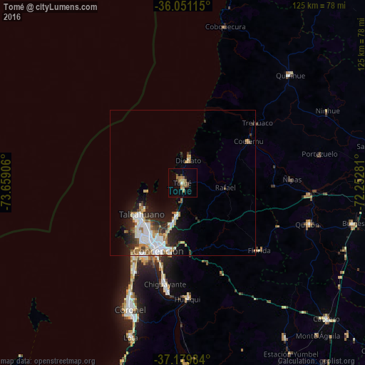
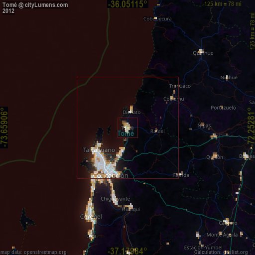
Analysis of Tomé night lights 2016
Square area 10x10 km:
 0.73%
0.73%90-99
0.18%80-89
2.75%70-79
1.83%60-69
4.21%50-59
3.11%40-49
1.83%30-39
2.2%20-29
0.18%10-19
2.93%0-9
80.04%Square area 50x50 km:
2.13%90-99
1.51%80-89
0.79%70-79
0.89%60-69
1.19%50-59
0.63%40-49
0.63%30-39
1.14%20-29
1.93%10-19
3.84%0-9
85.3%Clear (daylight) street map image can be seen on geolist.org.
Map coordinates:
36° 3' 4.1" South, 73° 39' 32.6" West
36° 37' 3.2" South, 72° 57' 21.3" West
37° 10' 47.4" South, 72° 15' 10.1" West
Some cities around Tomé sort by population:
• Talcahuano
18.7 km =11.6 mi,  230°
230°
• Concepción
24.7 km =15.3 mi,  199°
199°
• Coronel
49.1 km =30.5 mi, 199°
• Chiguayante
34.9 km =21.7 mi,  190°
190°
• Lota
55.5 km =34.5 mi, 198°
• Penco
14.1 km =8.8 mi, 194°
• Bulnes
60.2 km =37.4 mi,  103°
103°
• Quirihue
52.8 km =32.8 mi,  44°
44°
3869657 (p: 46,698)
Sources (retrieved 2019-11-25):
» Earth at Night: Flat Maps 2012, 2016