Teno night lights from space
Night Light of Teno (Maule Region) from space (Chile) Src. Average luminocity for 10x10km area is 18.1685% and for 50x50km: 6.4089%.
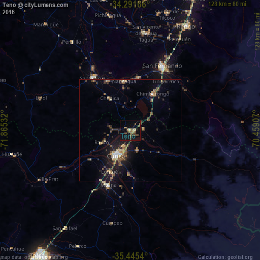
Analysis of Teno night lights 2016
Square area 10x10 km:
 0%
0%90-99
1.65%80-89
1.65%70-79
2.56%60-69
0.73%50-59
5.86%40-49
5.13%30-39
5.13%20-29
1.1%10-19
17.22%0-9
58.97%Square area 50x50 km:
0.25%90-99
0.44%80-89
0.81%70-79
0.62%60-69
0.95%50-59
1.55%40-49
0.96%30-39
1.64%20-29
1.68%10-19
5.1%0-9
85.99%Clear (daylight) street map image can be seen on geolist.org.
Map coordinates:
34° 17' 30" South, 71° 51' 55.2" West
34° 52' 14" South, 71° 9' 43.9" West
35° 26' 43.4" South, 70° 27' 32.7" West
Some cities around Teno sort by population:
• Curicó
14.3 km =8.9 mi,  209°
209°
• Rengo
58.6 km =36.4 mi,  28°
28°
• Santa Cruz
31.8 km =19.8 mi,  324°
324°
• San Vicente de Tagua Tagua
48.6 km =30.2 mi,  9°
9°
• Molina
29.2 km =18.1 mi,  201°
201°
• San Vicente
49.1 km =30.5 mi, 8°
• Chimbarongo
20.7 km =12.9 mi, 31°
• Rauco
15.4 km =9.6 mi,  246°
246°
3869979 (p: 6,858)
Sources (retrieved 2019-11-25):
» Earth at Night: Flat Maps 2012, 2016