Río Bueno night lights from space
Night Light of Río Bueno (Los Ríos Region) from space (Chile) Src. Average luminocity for 10x10km area is 7.7534% and for 50x50km: 1.2983%.
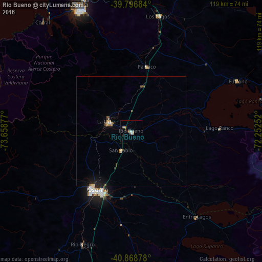
Analysis of Río Bueno night lights 2016
Square area 10x10 km:
 0.68%
0.68%90-99
2.04%80-89
0.17%70-79
1.19%60-69
1.02%50-59
1.7%40-49
0.68%30-39
0.51%20-29
1.36%10-19
0.34%0-9
90.31%Square area 50x50 km:
0.05%90-99
0.14%80-89
0.18%70-79
0.2%60-69
0.13%50-59
0.29%40-49
0.2%30-39
0.06%20-29
0.18%10-19
0.87%0-9
97.72%Clear (daylight) street map image can be seen on geolist.org.
Map coordinates:
39° 47' 48.6" South, 73° 39' 31.6" West
40° 20' 5.8" South, 72° 57' 20.3" West
40° 52' 7.6" South, 72° 15' 9.1" West
Some cities around Río Bueno sort by population:
• Osorno
30.5 km =19 mi,  209°
209°
• Valdivia
62.9 km =39.1 mi,  336°
336°
• Las Animas
62.6 km =38.9 mi, 339°
• La Unión
11.7 km =7.3 mi,  293°
293°
• Puerto Varas
109.5 km =68 mi,  181°
181°
• Panguipulli
93.4 km =58 mi,  34°
34°
• Loncoche
111.1 km =69 mi,  14°
14°
• Purranque
66.5 km =41.3 mi,  194°
194°
3873145 (p: 15,456)
Sources (retrieved 2019-11-25):
» Earth at Night: Flat Maps 2012, 2016