Wattwil night lights from space
Night Light of Wattwil (Saint Gallen) from space (Switzerland) Src. Average luminocity for 10x10km area is 1.9851% and for 50x50km: 5.4004%.
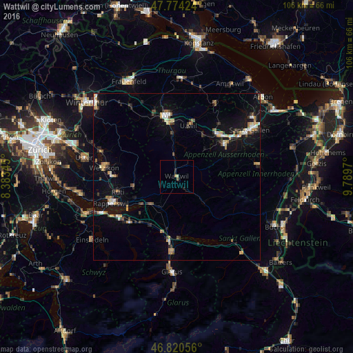
Analysis of Wattwil night lights 2016
Square area 10x10 km:
 0%
0%90-99
0.15%80-89
0.45%70-79
0.3%60-69
0.3%50-59
0.6%40-49
0%30-39
0%20-29
1.34%10-19
1.04%0-9
95.83%Square area 50x50 km:
0.48%90-99
0.71%80-89
0.6%70-79
0.79%60-69
0.72%50-59
0.39%40-49
0.86%30-39
0.63%20-29
1.01%10-19
4.23%0-9
89.59%Clear (daylight) street map image can be seen on geolist.org.
Map coordinates:
47° 46' 27.3" North, 8° 23' 0.4" East
47° 17' 58.4" North, 9° 5' 11.7" East
46° 49' 14" North, 9° 47' 22.9" East
Some cities around Wattwil sort by population:
• Gossau
18.1 km =11.2 mi,  44°
44°
• Herisau
17.4 km =10.8 mi,  56°
56°
• Uzwil
15.6 km =9.7 mi,  13°
13°
• Flawil
14.6 km =9.1 mi,  29°
29°
• Eschenbach
14.1 km =8.8 mi,  241°
241°
• Kirchberg
12.9 km =8 mi,  344°
344°
• Oberuzwil
14.9 km =9.3 mi, 11°
• Uznach
11.5 km =7.1 mi,  223°
223°
2658042 (p: 8,089)
Sources (retrieved 2019-11-25):
» Earth at Night: Flat Maps 2012, 2016