Uznach night lights from space
Night Light of Uznach (Saint Gallen) from space (Switzerland) Src. Average luminocity for 10x10km area is 2.4807% and for 50x50km: 5.1055%.
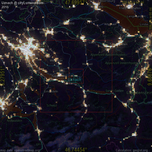
Analysis of Uznach night lights 2016
Square area 10x10 km:
 0%
0%90-99
0%80-89
0%70-79
0%60-69
0.3%50-59
0.3%40-49
1.79%30-39
1.19%20-29
0.89%10-19
0.74%0-9
94.79%Square area 50x50 km:
0.34%90-99
0.45%80-89
0.51%70-79
0.69%60-69
0.8%50-59
0.65%40-49
0.98%30-39
0.75%20-29
0.86%10-19
3.74%0-9
90.23%Clear (daylight) street map image can be seen on geolist.org.
Map coordinates:
47° 41' 58.5" North, 8° 16' 46.2" East
47° 13' 27.2" North, 8° 58' 57.5" East
46° 44' 40.3" North, 9° 41' 8.7" East
Some cities around Uznach sort by population:
• Jona
10.9 km =6.8 mi,  273°
273°
• Rüti
10.2 km =6.3 mi,  290°
290°
• Eschenbach
4.9 km =3 mi, 290°
• Wattwil
11.5 km =7.1 mi,  43°
43°
• Schübelbach
7 km =4.3 mi,  216°
216°
• Siebnen
8.5 km =5.3 mi,  229°
229°
• Lachen
10.4 km =6.5 mi,  250°
250°
• Altendorf
11.6 km =7.2 mi, 250°
2658210 (p: 5,561)
Sources (retrieved 2019-11-25):
» Earth at Night: Flat Maps 2012, 2016