Delémont night lights from space
Night Light of Delémont (Jura) from space (Switzerland) Src. Average luminocity for 10x10km area is 17.6399% and for 50x50km: 12.7482%.
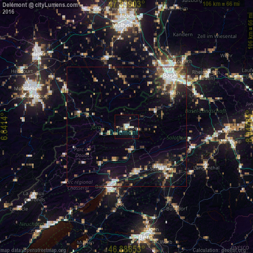
Analysis of Delémont night lights 2016
Square area 10x10 km:
 1.79%
1.79%90-99
3.72%80-89
2.68%70-79
1.04%60-69
2.08%50-59
0.6%40-49
2.53%30-39
2.23%20-29
2.23%10-19
10.71%0-9
70.39%Square area 50x50 km:
1.63%90-99
2.06%80-89
1.16%70-79
1.37%60-69
1.38%50-59
1.95%40-49
1.74%30-39
2.18%20-29
2.96%10-19
8.28%0-9
75.28%Clear (daylight) street map image can be seen on geolist.org.
Map coordinates:
47° 50' 20.5" North, 6° 38' 29" East
47° 21' 53.7" North, 7° 20' 40.3" East
46° 53' 11.5" North, 8° 2' 51.5" East
Some cities around Delémont sort by population:
• Grenchen
19.6 km =12.2 mi,  168°
168°
• Solothurn
22.7 km =14.1 mi,  140°
140°
• Aesch
22.4 km =13.9 mi,  58°
58°
• Therwil
21.9 km =13.6 mi,  46°
46°
• Moutier
9.8 km =6.1 mi, 168°
• Lengnau
20.5 km =12.7 mi,  175°
175°
• Porrentruy
21.1 km =13.1 mi,  286°
286°
• Laufen
13.3 km =8.3 mi, 61°
2661035 (p: 11,315)
Sources (retrieved 2019-11-25):
» Earth at Night: Flat Maps 2012, 2016