Allschwil night lights from space
Night Light of Allschwil (Basel-Landschaft) from space (Switzerland) Src. Average luminocity for 10x10km area is 58.0753% and for 50x50km: 17.7208%.
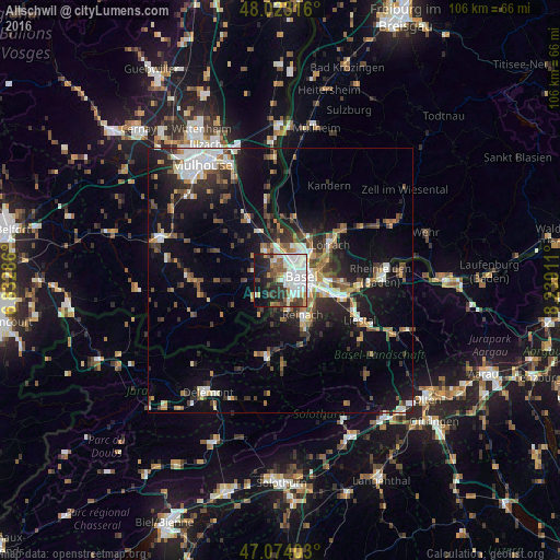
Analysis of Allschwil night lights 2016
Square area 10x10 km:
 18.47%
90-99
16.76%80-89
4.4%70-79
3.84%60-69
3.69%50-59
7.1%40-49
5.4%30-39
8.24%20-29
11.22%10-19
16.48%0-9
4.4%Square area 50x50 km:
2.95%90-99
2.88%80-89
1.32%70-79
1.71%60-69
1.95%50-59
2.7%40-49
2.6%30-39
3.32%20-29
4.9%10-19
12.52%0-9
63.17%Clear (daylight) street map image can be seen on geolist.org.
Map coordinates:
48° 1' 23.4" North, 6° 49' 58.3" East
47° 33' 2.7" North, 7° 32' 9.6" East
47° 4' 26.5" North, 8° 14' 20.8" East
Some cities around Allschwil sort by population:
• Basel
2.9 km =1.8 mi,  73°
73°
• Saint-Louis, FR
4.9 km =3 mi,  20°
20°
• Binningen
2.8 km =1.7 mi,  115°
115°
• Münchenstein
6.6 km =4.1 mi, 122°
• Birsfelden
6.6 km =4.1 mi,  87°
87°
• Oberwil
4.4 km =2.7 mi,  158°
158°
• Therwil
5.9 km =3.7 mi, 164°
• Bottmingen
4.1 km =2.5 mi,  138°
138°
2661810 (p: 18,189)
Sources (retrieved 2019-11-25):
» Earth at Night: Flat Maps 2012, 2016