Birsfelden night lights from space
Night Light of Birsfelden (Basel-Landschaft) from space (Switzerland) Src. Average luminocity for 10x10km area is 72.1648% and for 50x50km: 16.9638%.
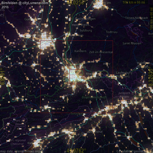
Analysis of Birsfelden night lights 2016
Square area 10x10 km:
 23.58%
90-99
20.74%80-89
5.97%70-79
7.81%60-69
6.11%50-59
8.95%40-49
6.68%30-39
8.38%20-29
11.22%10-19
0.57%0-9
0%Square area 50x50 km:
2.91%90-99
2.8%80-89
1.22%70-79
1.67%60-69
1.97%50-59
2.55%40-49
2.48%30-39
3.08%20-29
4.66%10-19
10.97%0-9
65.7%Clear (daylight) street map image can be seen on geolist.org.
Map coordinates:
48° 1' 31.1" North, 6° 55' 12.4" East
47° 33' 10.4" North, 7° 37' 23.6" East
47° 4' 34.3" North, 8° 19' 34.9" East
Some cities around Birsfelden sort by population:
• Basel
3.8 km =2.4 mi,  279°
279°
• Weil am Rhein, DE
4.5 km =2.8 mi,  357°
357°
• Riehen
3.4 km =2.1 mi,  31°
31°
• Muttenz
3.7 km =2.3 mi,  153°
153°
• Binningen
4.3 km =2.7 mi,  250°
250°
• Grenzach-Wyhlen, DE
4.5 km =2.8 mi,  94°
94°
• Münchenstein
4 km =2.5 mi,  194°
194°
• Bottmingen
5 km =3.1 mi,  229°
229°
2661490 (p: 10,232)
Sources (retrieved 2019-11-25):
» Earth at Night: Flat Maps 2012, 2016